 Route Editor

| Guide | ♦ | 17 Triplogs | 0 Topics |
details | drive | permit | forecast | route |
stats |
photos | triplogs | topics | location |
| 2 | 17 | 0 |
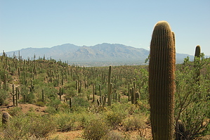
Saguaros, Saguaros lots of Saguaros by markthurman53  Overview OverviewThis is a short 0.9-mile hike starting at the junction of the Thunderbird Trail and the Gila Monster Trail. The trail heads to the north from this trail junction up a short canyon to a saddle that separates this drainage system from the Picture Rocks Wash drainage system. Once on the saddle, the trail continues north passing the Coyote Pass Trail junction and then drops into the Picture Rocks Wash where the trail ends. Hike The Cactus Canyon Trail starts where the Thunderbird Trail ends. The Gila Monster Trail also starts at this Point and heads east. The trail is signed for the Cactus Forest Trail but indicates nothing about the Gila Monster Trail. From this trail junction, the trail heads north up a small canyon to a saddle that separated this drainage system from the Picture Rocks Wash drainage system. This saddle is about 70 feet above the trail start and once at the saddle you’re not cone climbing, the trail continues to climb another 40 feet along the west slope of a hill before dropping down toward the Picture Rocks Wash. Not sure why the trail continues to climb after the saddle doesn’t seem like it is necessary. Once past the high point of the trail, it heads down toward the signed junction with the Coyote Pass Trail and then 0.2 miles later drops into the Picture Rocks Wash and end of the trail. This trail is also signed at this intersection. Cactus Canyon lives up to its name with hundreds of saguaros, not the best stand of saguaros I have seen but there are a lot. There are great views from the saddle both to the northwest and southeast. This trail has no trailhead and is, therefore, a trail used as part of a longer loop hike. Being there are numerous trails in this area the options are plentiful.
Check out the Official Route and Triplogs. Leave No Trace and +Add a Triplog after your hike to support this local community. One-Way Notice This hike is listed as One-Way. When hiking several trails on a single "hike", log it with a generic name that describes the hike. Then link the trails traveled, check out the example. | ||||||||||||||||||||||||||||||||||||||||||||||||||||||||||||||||||||||||||||||||||||||||||||||||||||||||||||||||||||||||||||||||||||||||||||||||||||||


