 Route Editor

| Guide | ♦ | 4 Triplogs | 1 Topic |
details | drive | permit | forecast | 🔥 route |
stats |
photos | triplogs | topic | location |
| 2 | 4 | 1 |
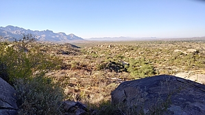
From South Gate to Middle Gate by markthurman53  Overview OverviewThis is a trail on the western slopes of the Catalina Mountains below Samaniego Ridge. Most of these trails in this area are used as mountain bike trails but do see some hikers, especially as you get higher up on the slopes of Samaniego Ridge. There is a maze of trails in this area. Many of them are not officially named routes. Signage in this area is nonexistent. This trail is entirely on National Forest, but access is from State Trust land, and a State Trust Land Permit may be required. The locals informed me that hiking in the area didn’t require a permit but parking on state Trust Land probably does. The rules for State Trust Land require that you get a permit if entering Trust Land. I went online and got a year pass for $15.00 to be on the safe side. The Majority of the trails in this area are on National Forest, but the Trailheads are on Trust Land. Access to the Middle gate Trail is from the Golder Ranch Road Trail Head. Description This trail starts on State Trust Land along the 50 Year Trail, where the dirt road crosses a cattle guard. This is the same trailhead used for the Baby Jesus Trail. There are no trail signs here, so knowledge of where the trails start is essential. From the trailhead, do not take the 50 Year Trail. The 50 Year Trail heads off to the east or west but stays to the north of the cattle guard. Instead, head to the southeast crossing the cattle guard and follow the dirt road for about 300 feet and take the trail that heads off to the east from the road. The Middle Gate trail heads east and crosses an unnamed wash, and 100 yards after that, it crosses Sutherland Wash. Once across the wash, you enter National Forest land. This trail is 2.5 miles long and has an elevation gain of about 300 feet in the first 1.3 miles, and then the next 1.2 miles drops back down almost all of the 300 feet where it ends at the middle gate on the 50 Year Trail. This trail is heavily used by mountain bikers and is easy to follow. Middle Gate Trail follows along the lower hills and parallels Sutherland Wash, and its main attraction are the boulders that the trail winds through. The hike's last half is downhill and enters a wash and small canyon that will lead to the 50 Year Trail. From this trail, the Cherry Tank Trail can be accessed along with the 50 Year Upper Trail. Other than the boulders and a short stretch along the wash leading to the 50 Year trail, there is not much on this trail. Views other than Samaniego Peak and Ridge are minimal due to the lack of any elevation. This trail can be used as a connector trail to other trails. Gate Policy: If a gate is closed upon arrival, leave it closed after you go through. If it is open, leave it open. Leaving a closed gate open may put cattle in danger. Closing an open gate may cut them off from water. Please be respectful, leave gates as found. The exception is signage on the gate directing you otherwise. Check out the Official Route and Triplogs. Leave No Trace and +Add a Triplog after your hike to support this local community. One-Way Notice This hike is listed as One-Way. When hiking several trails on a single "hike", log it with a generic name that describes the hike. Then link the trails traveled, check out the example. | |||||||||||||||||||||||||||||||||||||||||||||||||||||||||||||||||||||||||||||||||||||||||||||||||||||


