 Route Editor

| Guide | ♦ | 1 Triplog | 1 Topic |
details | drive | permit | forecast | 🔥 route |
stats |
photo | triplog | topic | location |
| 1 | 1 | 1 |
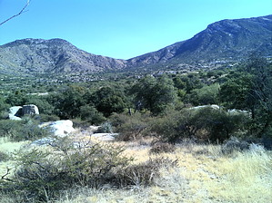
Transition from desert to grassland by markthurman53  Overview OverviewThis is a trail on the western slopes of the Catalina Mountains below Samaniego Ridge. Most of these trails in this area are used as mountain bike trails but do see some hikers, especially as you get higher up on the slopes of Samaniego Ridge. There is a maze of trails in this area. Many of them are not officially named routes. Signage in this area is nonexistent. This trail is entirely on National Forest, but access is from State Trust land, and a State Trust Land Permit may be required. The locals informed me that hiking in the area didn’t require a permit but parking on state Trust Land probably does. The rules for State Trust Land require that you get a permit if entering Trust Land. I went online and got a year pass for $15.00 to be on the safe side. The Majority of the trails in this area are on National Forest, but the trailheads are on Trust Land. Accessing this trail is from the Golder Ranch Road Trail Head via the Middle Gate and 50 Year Upper Trail. This trail may also be accessed indirectly from Cherry Tank Trail on the Charouleau Gap Road, on National Forest land. The Charouleau Gap Road is a rough 4WD road, and in places not sure I would call it a road even for high clearance 4WD. Description This trail starts at the triple junction of the 50 Year Trail, the 50 Year Upper Trail and the Gem Trail. All three Trails start or end here. About 200 feet east of this junction along the 50 Year Upper Trail, the Cherry Tank Upper Trail heads northeast, following along the northernmost tributary of Sutherland Wash. The trail almost immediately crosses to the east side of this creek and continues to climb a small ridge before dropping back down and crossing back over to the west side of the creek. This trail is 1.6 miles long and has an elevation gain of 400 feet. The trail skirts around the north side of a granite hill with a peak of 4175 feet but stays well below the summit. It ends on the east side of this hill at about the midpoint on the Cherry Tank Trail. This trail transitions from the Sutherland Wash Drainage to the Dodge Tank Drainage, which dumps directly into Canada Del Oro Wash.
Check out the Official Route and Triplog. Leave No Trace and +Add a Triplog after your hike to support this local community. One-Way Notice This hike is listed as One-Way. When hiking several trails on a single "hike", log it with a generic name that describes the hike. Then link the trails traveled, check out the example. | |||||||||||||||||||||||||||||||||||||||||||||||||||||||||||||||||||||||||||||||||||||||||||||||||||||


