Route Editor

| Guide | ♦ | 2 Triplogs | 1 Topic |
details | drive | permit | forecast | route |
stats |
photos | triplogs | topic | location |
| 45 | 2 | 1 |
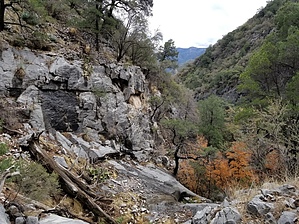
scheelite's cousin by CB2L   Overview OverviewAn out-and-back trail on the Fort Huachuca Reservation in the Miller Peak Wilderness Area. A vehicle with good ground clearance and preferably 4WD helps reach the marked start of McClure Canyon about a half-mile from the turn-off from Garden Canyon Road. Otherwise, starting from the turn-off is also a good hike. Hike Trail starts as an unimproved road before narrowing to a path suitable for foot traffic only for the ascent to the crest, where a hiker can likely reach Huachuca Peak. Trail is mostly shaded, though there are exposed sections higher up. The difficulty is moderate, with approximately 2000 feet of elevation gain. Unlike nearby Scheelite Canyon Trail, there are no portions where scrambling/climbing is absolutely necessary, though quick jaunts off-trail for scrambling can be made. Check out the Official Route and Triplogs. Leave No Trace and +Add a Triplog after your hike to support this local community. | ||||||||||||||||||||||||||||||||||||||||||||||||||||||||||||||||||||||||||||||||||||||||||||||||