 Route Editor

| Guide | ♦ | 3 Triplogs | 0 Topics |
details | drive | no permit | forecast | route |
stats |
photos | triplogs | topics | location |
| 50 | 3 | 0 |
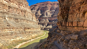
Hiker Tetris by chumley  The Honaker Trail was constructed beginning in 1893 by gold prospector Augustus Honaker as a way to access his claim along the river 1200 feet below the rim. Like other prospectors in the area, Honaker never struck gold, and thus his trail never paid off. Years later however, this rough supply route was improved by geologists studying the fascinating layers of rock visible in the deep canyon cut by the San Juan River. Even today, hikers can readily spot large painted numbers along the route that identifies the various rock layers as you pass through them.
This historic trail has existed for so long that geologic assessments of the layers across southern Utah actually have named one of the layers the Honaker Trail Formation. In 1979, the USGS officially added the trail name to the Geographic Names Information System. You’ll find that the trail is marked and its name written on USGS topographical maps going back as early as 1963. Hike A dirt road leads to the edge of the canyon rim where the beginning of the trail is marked by a 4-foot high rock cairn. Some 4x4 vehicles can make it to the edge, but most hikers will start the hike 200 yards before the road ends, which avoids driving over the challenging rock steps. From the canyon rim, the route begins a steady descent toward the southwest, before four switchbacks zig and zag as you drop the first 200 feet. Already you will have passed several painted numbers identifying different geologic layers. If geology interests you, there are sources of research online that you should seek out which will identify the various layers. Geology isn’t my strong point, so I won’t attempt to add that information here! The next half mile drops 300 feet while passing through numerous layers of geology and keeping on a southwesterly path toward the ridge leading to the bend in the river. A few short switchbacks drop an additional 150 feet to the magnificent Horn Point at about the 4,500 foot contour. The view from the end of Horn Point is worth it, so make sure to take a break here before continuing down. The trail below Horn Point is an illustration in unbelievable trail construction. Two major levels are descended through narrow slots heavily built up with steep ramps supported by large stone walls. Again, numbers painted on the rock identify the geologic layers you are descending through. Down 200 feet from Horn Point, the trail now makes a major half-mile long traverse paralleling the river headed downstream. The views here are amazing, and though the trail is nicely cut with tread that is flat and reasonably wide, the drop is sheer and far, so those with a fear of heights might find this section to be a bit unnerving. Next, three switchbacks drop through additional layers, connected by relatively short 200 yard traverses between them. There’s nearly a half mile traverse back toward the river under Horn Point, with two quick switchbacks that drop the final layers to the beach, arriving at the Honaker campsite along the river. A mess of trails along the shore lead both up and downstream allowing you to explore, relax, and take a dip in the river. After you’ve had a chance to relax, retrace your steps by heading back the way you came! Caution This trail has no shade, and while the trail is not exposed to early morning sun due to the steep canyon walls, it will certainly be in sunshine by a couple of hours after sunrise when most hikers will be on the trail. The midday sun bakes the surrounding rock and holds the heat into the evening. There is water available at the San Juan River, but it is often very turbid and difficult to filter. It would be more reliable to carry and/or cache water from the beginning. Camping BLM manages the land on this side of the river and camping is permitted and free. Rafting parties are common here. The other side of the river is Navajo land, and a permit is required to hike or camp on the opposite shore. Check out the Official Route and Triplogs. Leave No Trace and +Add a Triplog after your hike to support this local community. One-Way Notice This hike is listed as One-Way. When hiking several trails on a single "hike", log it with a generic name that describes the hike. Then link the trails traveled, check out the example. | |||||||||||||||||||||||||||||||||||||||||||||||||||||||||||||||||||||||||||||||||||||


