username
X
password
register
for free!
help
  This is likely a great time to hike this trail!  Check out "Preferred" months below, keep in mind this is an estimate.
  

Beauty Carlin Trail #257, ID

Guide 3 Triplogs  0 Topics
  5 of 5  
Fav
Wish
0
details
drive
permit
forecast
route  
stats
photos
triplogs
topics
location
14 3 0
Statistics
tap row or icons for details
Difficulty 2 of 5
Route Finding 2 of 5
Distance One Way 2.65 miles
Trailhead Elevation 2,622 feet
Elevation Gain 1,154 feet
Accumulated Gain 1,270 feet
Avg Time One Way 1.50 hrs
Kokopelli Seeds 6.88
 Interest Seasonal Creek & Perennial Creek
 Backpack Possible - Not Popular
feature photo
Photos Viewed All MineFollowing
10  2024-06-13
Mt Coeur d'Alene via Beauty Carlin Trail
LindaAnn
14  2023-09-29
Mt Coeur d'Alene via Beauty Carlin Trail
LindaAnn
Author
author avatar Guides 110
Routes 2,246
Photos 8,982
Trips 2,600 map ( 15,998 miles )
Age 45 Female Gender
Location Ahwatukee, AZ
Associated Areas
list map done
Northern Region
Historical Weather
Trailhead Forecast
Radar Map
Expand Map
Preferred Jun, Jul, Aug, Sep
Seasons   Summer to Autumn
Sun  6:10am - 7:19pm
Official Route & 1 Rt
 
3 Alternative


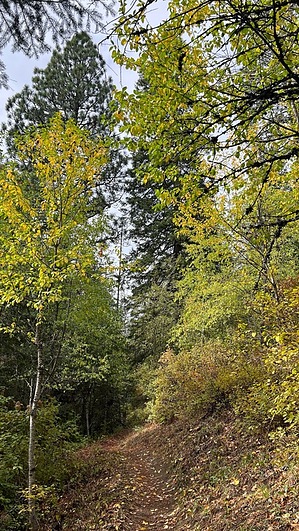
relaxing stroll among abundant sunblock
by LindaAnn

  Likely In-Season!
Overview: Moderately easy hike up the east side of Mt Coeur d'Alene, also popular with mountain bikers.


Hike: From the parking area on the east side of Beauty Creek Rd, cross over to the west side of the road at the brown trail sign. The trail immediately drops down to Beauty Creek and crosses over it. Late spring/early summer snowmelt may make for a challenging crossing, but you can keep your feet dry any other time of the year. Once across the creek, the trail turns to the right and heads uphill.
remove free decal offer
The forest is dense with pines, cedar, hemlock, and a large variety of other trees, which block most of your views. Shade is abundant, even in summer. A sharp bend in the trail gives a few views to the north before you turn to the southwest and continue heading uphill. The trail is in good condition and is never steep as you continue ascending the eastern slopes of Mt Coeur d'Alene.

At about 1.70 miles, the trail reaches an old road, which is the junction with Trail 258. Turn left on the road to continue on Beauty Carlin Trail (trail 258 contours around to the north side of the mountain, eventually connecting with Caribou Ridge Trail #79, which does allow for a lollipop loop option) as it quickly transitions from road back to singletrack.

Shortly after this junction, the trail crosses a small seasonal creek, then continues uphill, eventually reaching its terminus at FS-439. While views are limited for the entirety of the trail, mountain bikers keep the trail in good condition and clear of deadfall, allowing for a relaxing hike through the forest.

2023-09-29 LindaAnn


    Check out the Official Route and Triplogs.
    Leave No Trace and +Add a Triplog after your hike to support this local community.

    One-Way Notice
    This hike is listed as One-Way.

    When hiking several trails on a single "hike", log it with a generic name that describes the hike. Then link the trails traveled, check out the example.
    WARNING! Hiking and outdoor related sports can be dangerous. Be responsible and prepare for the trip. Study the area you are entering and plan accordingly. Dress for the current and unexpected weather changes. Take plenty of water. Never go alone. Make an itinerary with your plan(s), route(s), destination(s) and expected return time. Give your itinerary to trusted family and/or friends.

     Permit $$
    FS
    Backpacking camping permits: request 2 weeks in advance


     Directions
    or
     Road
    Paved - Car Okay

    To hike
    From Coeur d'Alene, take I-90 east to exit 22 Hwy 97. Turn right and take Hwy 97 south for 2.35 miles to Beauty Creek Rd. Turn left on Beauty Creek Rd and take east for 3.20 miles to the start of the trail, which is marked by a brown wooden sign in poor condition on the right side of the road. There is room for about 3 vehicles to park on the left side of the road, immediately across from the sign.
    page created by joebartels on Sep 29 2023 5:57 pm
     90+° 8am - 6pm kills
    helpcorrectionissue

    end of page marker