Route Editor

| Guide | ♦ | 4 Triplogs | 0 Topics |
details | drive | no permit | forecast | route |
stats |
photos | triplogs | topics | location |
| 34 | 4 | 0 |
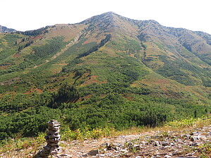
Switchbacks? We don't need no stinking switchbacks! by ddgrunning The hike starts at the Y Mountain Trailhead, with wide, groomed, but steep switchbacks heading up the popular local trail to the large "Y" on the side of the mountain, representing the BYU campus below. On a Saturday morning, this part of the hike is unsurprisingly crowded. Every one of the 13 switchbacks is numbered and signed with distance, elevation, factual tidbits, and encouragement for the casual hikers to keep plugging away to the top. The "top" of the Y is reached in a little over a mile of work, with about 1,000 ft. of elevation gained. The crowds are deservedly satisfied with the accomplishment of conquering the Y and taking in beautiful vistas of the city below, with Utah Lake on the far side of the valley, Mt. Timpanogos towering over the valley to the North, and a panoramic view of the Utah Valley below.
At the top of the Y, the trail continues up and around the side of Y Mountain, at a slightly more moderate grade, into Slide Canyon. On the day of my hike, as I rounded the corner into Slide Canyon, I had my wildlife sighting for the day--a large, bighorn sheep, bounding up the south-facing side of the canyon with ease, and casting aspersions in the general direction of what mere humans consider "steep." Just before the 3-mile mark, a use trail forks off to the left, giving access to a steep, switchback-less climb up to the top of Y Mountain. A worthy endeavor of its own, but we have our sights on bigger fish this day. Staying the course up through Slide Canyon, it serpentines around the unnamed Peak 9,089 that neighbors Y Mountain to the First Right Fork Canyon Trail Junction. This section of trail travels through some nice aspen groves. It clearly gets much less use and was heavily overgrown with fairly thick, waist-to-shoulder height foliage--mostly some variety of sunflower with leaves about 2.5 times the size of my hand. Unfortunately, during my mid-August visit, the petals had mostly fallen off the flower heads--surely, the "full-petal" experience would have been even more spectacular. The "jungly-type" stroll through the foliage was thick in parts but does not slow you down--compared to the AZ manzanitas, this was like walking through plush velvet. Following the flower jungle stroll, the trail intersects with the Slate Canyon Trail junction, which provides an alternate approach to Provo Peak and can be hiked in a loop, connected by the Bonneville Shoreline Trail that skirts the bottom of the Wasatch Mountains. At the Slate Canyon Trail junction, hand a sharp left and head up and around the unnamed 9001-ft. peak that stands in the way of your final destination. As the trail rises from the "canyon" and around the side of Peak 9001, the views of Mt. Timpanogos, Rock Canyon, the top of Y mountain, and northerly vistas come into view. Rounding the north side of Peak 9001, the trail enters into a beautiful forested area, with large fir trees that eventually break into another worthy aspen grove. As you crest the final ridgeline around Peak 9001, the imposingly steep approach to Provo Peak finally comes into view for the first time. Unfortunately, you have to drop (and then regain) nearly 400 feet, to bridge the ravine that separates Provo Peak from Peak 9001. At the base of the dividing ravine is Squaw Peak Road, which is a dirt road that provides more direct access to the Provo Peak Trailhead, for those looking for a shortcut to the "stair-climber." Having crossed the road, you are now at the official "start" of the Provo Peak ascent--at 8,340 feet, the road sits a mere 1.25 miles away from the 11,068-summit, with only 2700+ feet of climbing separating you from its 360-degree, alpine views. From here, it's just UP--no switchbacks, no mercy--just UP! If you eat contour lines for breakfast, the smorgasbord awaits. Following some huffing and puffing, you eventually reach the weather-vane-crowned summit. The summit weather vane was well constructed, with mirrors on the fin and what used to be a propeller on the front end. The blades are broken off at the welds, but it still spins nicely. After taking in the panoramic vistas, return the way you came (or take the Slate Canyon option and loop back on Bonneville Shoreline Trail). Though less taxing on the lungs, the steep descent on the return is every bit as hard on the quads/toes going down as it was on the calves going up. Check out the Official Route and Triplogs. Note This is a difficult hike. It would be insane to attempt this entire hike without prior experience hiking. Leave No Trace and +Add a Triplog after your hike to support this local community. | |||||||||||||||||||||||||||||||||||||||||||||||||||||||||||||||||||||||||||||||||||||