 Route Editor

| Guide | ♦ | 43 Triplogs | 0 Topics |
details | drive | permit | forecast | route |
stats |
photos | triplogs | topics | location |
| 180 | 43 | 0 |
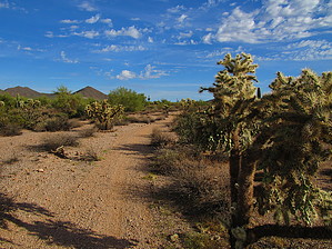
Only sheep could get lost here by CannondaleKid  Overview OverviewAn easy trail from the Visitor Center to the SW 'corner' of Moon Rock Trail. It has a slow and steady elevation loss with the south end 164 feet lower than the start. (So, if you do an out-and-back you will have a total of 164' AEG.) Warning The usual... watch for the usual sharp stuff like cholla balls on the trail and of course watch/listen for rattlesnakes.
I believe it is a 'new' trail for 2018. I am assuming it was named for the odd 'lost sheep' during the biannual sheep drives through the park. The drives used to move about 4,000 sheep to San Tan Valley in the fall and back to Heber in the spring. While the Lost Sheep Trail is not yet shown on the official Usery Park pdf map, it is shown on the Maricopa County Regional Parks interactive map. (Note: you will need to zoom in some distance to see this trail on the map.) Hike Very easy... just like a walk-in-the-park, except with no shade to be had. Mountain Bike A steady slight downhill on a relatively smooth hard-packed dirt single-track, with just a few very short wash crossings... not enough sand to be a problem. Water Sources On the trail? Dry as a bone! At the TH? Plenty of water at the Visitor Center. Camping Elsewhere in the park at designated sites with a permit, but not along the trail.
Check out the Official Route and Triplogs. Leave No Trace and +Add a Triplog after your hike to support this local community. One-Way Notice This hike is listed as One-Way. When hiking several trails on a single "hike", log it with a generic name that describes the hike. Then link the trails traveled, check out the example. | |||||||||||||||||||||||||||||||||||||||||||||||||||||||||||||||||||||||||||||||||||||||||||||||||||||||||||||||||||||||||||||||||||||||||||||||||||||||||||||||||||||


