username
X
password
register
for free!
help
 
   🔥

Cottonwood BM 7481, AZ

Guide 6 Triplogs  0 Topics
  4 of 5  
Fav
Wish
0
details
drive
permit
forecast
🔥
route  
stats
photos
triplogs
topics
location
26 6 0
Statistics
tap row or icons for details
Difficulty 1 of 5
Route Finding 3 of 5
Distance Round Trip 1.52 miles
Trailhead Elevation 7,266 feet
Elevation Gain 201 feet
Accumulated Gain 298 feet
Avg Time Round Trip 1 hour
Kokopelli Seeds 3.01
 Interest Off-Trail Hiking & Peak
feature photo
Photos Viewed All MineFollowing
Will recalculate on button tap!
87  2024-05-06
Cottonwood Mountain Trail #66 - Santa Teresas
Mike_W
6  2020-10-11 AugustWest
7  2020-10-11
Cottonwood Mountain Trail #66 - Santa Teresas
LindaAnn
7  2019-03-10 RedwallNHops
13  2018-12-09
Cottonwood Mountain Trail #66 - Santa Teresas
chumley
Author
author avatar Guides 595
Routes 0
Photos 0
Trips 247 map ( 429 miles )
Age ?
Location
Associated Areas
list map done
Tucson Region
Historical Weather
Trailhead Forecast
Radar Map
Expand Map
Preferred Nov, Dec, Jan, Feb
Sun  5:57am - 6:42pm
Official Route & 1 Rt
 
2 Alternative
 
Historic Fire Perimeteracres
🔥 2021 Pinnacle77.7 mi*


remove free decal offer

 
Guide Needed
Publish Full Detail Guide


Use +Add above to share photos and triplogs
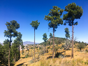
There is a faint, occasionally cairned old use trail from the saddle where Trail #66 crests Cottonwood Mountain. A register and benchmark can be found on the summit.


    Check out the Official Route and Triplogs.
    Leave No Trace and +Add a Triplog after your hike to support this local community.
    WARNING! Hiking and outdoor related sports can be dangerous. Be responsible and prepare for the trip. Study the area you are entering and plan accordingly. Dress for the current and unexpected weather changes. Take plenty of water. Never go alone. Make an itinerary with your plan(s), route(s), destination(s) and expected return time. Give your itinerary to trusted family and/or friends.

     Permit $$
    None

    Coronado Forest
    MVUMs are rarely necessary to review unless mentioned in the description or directions
    Coronado Motor Vehicle Use Maps (MVUMs)


     Directions
    or
     Road
    Connector trail - Not Applicable

    To hike
    page created by chumley on Dec 10 2018 10:57 am
     90+° 8am - 6pm kills
    helpcorrectionissue

    end of page marker