Route Editor

| Guide | ♦ | 1 Triplog | 0 Topics |
details | drive | permit | forecast | 🔥 route |
stats |
photos | triplog | topics | location |
| 9 | 1 | 0 |
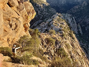
An echoey bushwack by jajohnson11  Overview OverviewPeak 5110 is an off-trail bushwhack to the summit of the peak labeled "5110" on USGS 7.5 maps southeast of Romero Pools. The bighorn restriction applies to this hike, so it is off-limits from January 1st- April 30th. Warning The cross country section includes making your way through dense vegetation and the occasional obstacle. The summit approach includes class 3 scrambling with exposure and a class 4 obstacle to get to the summit. This hike is for experienced hikers with good route-finding capabilities.
Park at the easternmost parking lot at Catalina State Park and head up the Romero Canyon Trail. Enjoy seeing other hikers on your way up to Romero Pools because you will most likely have the rest of the place to yourself! Soon into the hike on Romero Canyon trail, peak 5110 will come clearly into view. It appears impossible to reach the summit without technical gear from the front, but have no fear as the saddle comes into view after Romero Pools. The route that we chose was not the drainage that connects the saddle to Romero Creek but instead, we aimed to hit the base of the summit's rock formation and contour southeast over to the saddle, which worked well for us. It is probably possible to directly follow the drainage, but you would need to stay on the trail and then cross the creek. After leaving the trail, the route to the saddle is very time-consuming (3.5 of our 7 hours were spent going up and down this section) and requires going through some patches of very dense vegetation. The usual for Catalina bushwhacks, but this one seemed to be more dense vegetation than fields of shin daggers like some of the south-facing slopes out of Pima canyon (Table Mtn, the Cleaver, Prominent Pt.) The route is not cairned. There are no cairns anywhere on this hike, so it's a true cross country route choice to the top. We eyed scrambling up some rock to cheat directly to the base, but that would involve scrambling up some long steep sections where a fall could be fatal, so we opted for the safe route to the saddle. Once at the saddle, you're almost done! The route choices are minimal here, and some class 3 obstacles immediately await. The final route to the top leaves you only one option, scrambling up the left side. The last obstacle to reach the top is the crux, a class 4 (or upper C3) obstacle has some very loose rock, so be careful. In our group of three, two of us chose the route to the right, which put our backs to some exposure, while the 3rd chose to wiggle up the left. This seemed more difficult but would be safer in the event of a fall. Once at the summit enjoy great views of the Sutherland Ridge and Samaniego Ridges to the North, and to the South an up-close view of peak 5791, and all the other major Catalina landmarks. We brought a summit register in case there wasn't one, but there is already a register up there with about 15 entries. Frank has signed the register seven times by our count. Soak in the views from a summit where few have been! Check out the Official Route and Triplog. Note This is a moderately difficult hike. Leave No Trace and +Add a Triplog after your hike to support this local community. | |||||||||||||||||||||||||||||||||||||||||||||||||||||||||||||||||||||||||||||||||||||||||||||||||||||||||||||