 Route Editor

| Guide | ♦ | 29 Triplogs | 0 Topics |
details | drive | no permit | forecast | route |
stats |
photos | triplogs | topics | location |
| 191 | 29 | 0 |
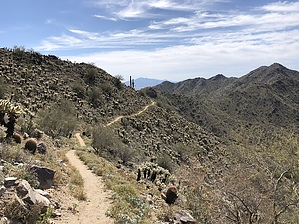
No fooling around, this one's a gem by LindaAnn  Overview: Overview:A pleasant, lesser-traveled trail along the western edge of the Skyline trail system. Getting there: From the main parking area, head north across the bridge then left on Mountain Wash Trail for 0.20 miles. Turn left on Turnbuckle Trail for 0.40 miles. Then left on Granite Falls Trail for 0.80 miles to the signed beginning of Pyrite Trail on the left. At this point, you will have hiked approx 1.40 miles with probably only about 100' of elevation gain.
Once you are on Pyrite, you will initially head south, then gradually southwest, crossing a couple of dry washes. The trail has a very gradual incline for the first half-mile, turning to the west. The incline for the next quarter mile slowly increases as the trail turns north-northwest. After that, the trail steadily climbs uphill at a pleasant incline-not too steep, and the trail condition is very good. Views to the west are nice, and hiking the upper portions of the trail is very enjoyable. At the high point of the trail, approx 1.75 miles in, you can turn left to make the short side trip up to Pyrite Summit. After the high point, the trail drops down steeply to the north, ending at the junction with Chuckwalla Trail in less than half a mile. There's some loose rock in places, but overall trail conditions are good. At the Chuckwalla junction, there are three options: 1-You can turn around to retrace your steps on Pyrite if you want to climb back up the steep hill you just descended. 2-Turn right on Chuckwalla to make a short loop towards the trailhead. 3-Turn left on Chuckwalla to make a larger loop utilizing additional trails in the park. Note: Pyrite Trail is fairly far from the trailhead. Hiking the full trail, plus connecting trails, requires a minimum of 7.40 miles of hiking. Temperatures can get very warm, especially during the summer. Make sure to carry enough water.
Check out the Official Route and Triplogs. Leave No Trace and +Add a Triplog after your hike to support this local community. One-Way Notice This hike is listed as One-Way. When hiking several trails on a single "hike", log it with a generic name that describes the hike. Then link the trails traveled, check out the example. | |||||||||||||||||||||||||||||||||||||||||||||||||||||||||||||||||||||||||||||||||||||||||||||||||||||||||||||||||||||||||||||||||||||||||||||||||||||||||||||||||||||||||||||||||||||||||


