 Route Editor

| Guide | ♦ | 4 Triplogs | 0 Topics |
details | drive | permit | forecast | 🔥 route |
stats |
photos | triplogs | topics | location |
| 25 | 4 | 0 |
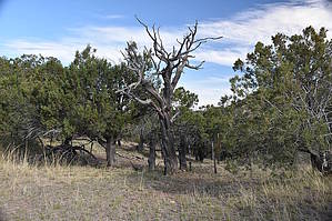
Forgotten but not lost by markthurman53  Overview OverviewThe Lyle Canyon Trail follows along and below the Huachuca Mountains' northernmost ridge. This trail has very little to do with Lyle Canyon other than it crosses over it at one point. From the north, the trail bridges Brushy Canyon Road, Forest Service Road 202 with Sunnyside Canyon Road to the south. The trail is reasonably level, with an elevation gain of about 1000 feet if coming from the north. Midway through the trail is the junction with the Huachuca Peak Trail and a route that follows down Lyle Creek to Lyle Canyon Road. It crosses three streams, Lyle, Parker, and Merritt creeks, not counting Korn Creek at the north end and Scotia Creek at the south end. This trail is not heavily traveled, so it is a bit faint in sections but overall easy to follow. The forests are mainly Oak and Juniper, with sycamore in some of the creeks. There are some magnificent Juniper trees along the trail, not the largest I’ve seen but still grand. This is an excellent trail to do in spring, fall, and winter. Hike The trailhead is at the end Of Brushy Canyon Road (Forest Service Road 202) at Korn Canyon from the north. All but the last half mile of this 5 miles road is doable in a passenger car, and the rest requires high clearance. From the end of the road at Korn Canyon, follow the road's remnants 100 yards down into Korn Creek, and a trail, though faint, will be seen exiting the creek on the south side. The trail follows a faint two-track for a while, and then it gradually fades away into a single track. At 0.7 miles, the trail crosses over a small ridge, and just to the west of the trail are two empty steel water troughs for cattle. To the immediate west of the trail is a barbed wire fence, and the trail follows alongside much of the way, making it easy to locate the trail. This trail doesn’t get a lot of use, and when it does, it is probably from those maintaining the fence line. The next 0.3 miles is relatively level until the Lyle Creek crossing. The first sycamore trees along this trail are in this canyon. There is a route coming up Lyle canyon from the west at this point that starts lower down the canyon at Lyle Canyon Road. There was a small flow in Lyle creek on this trip, so there were deer and turkeys. From here to the junction with Huachuca Peak Trail (0.7 miles), the trail climbs 200 feet. At 1.8 miles in is the junction with the Huachuca Peak Trail.
From the south end, the Trail is 3.2 miles in on the Sunnyside road, 0.5 miles past the Arizona Trail crossing. This road is passenger car-friendly, with possibly the last 0.2 miles being high clearance. The trailhead is not signed on the road but is about 100 feet in on the trail. Look for an old two-track heading off to the left (north). If you start a steep climb out of the creek bottom, you have gone too far by a hundred feet or so. This is the trail to take to get to the Huachuca Peak Trail. There are three options though, Lyle Canyon Trail from the north Lyle Canyon from the south, or Lyle Creek route from the west at Lyle Canyon Road. All options are about the same distance to the Huachuca Peak Trail. Coming in from the north requires that 5-mile drive along Brushy Canyon Road, a rocky forest road, but the hike in is easy. Option 2 coming in from the south, still a five or so mile drive along a reasonably good dirt road (Montezuma Canyon and Sunnyside Road), much easier than Brushy Canyon Road. On this option, the trail does require a 500-foot climb. Option 3 takes Lyle Canyon Road, an excellent dirt road to Lyle Canyon, and head upstream. There are no hills to climb, and the route, while not a trail, appears to be used enough to make it easy to follow. Gate Policy: If a gate is closed upon arrival, leave it closed after you go through. If it is open, leave it open. Leaving a closed gate open may put cattle in danger. Closing an open gate may cut them off from water. Please be respectful, leave gates as found. The exception is signage on the gate directing you otherwise. Check out the Official Route and Triplogs. Leave No Trace and +Add a Triplog after your hike to support this local community. One-Way Notice This hike is listed as One-Way. When hiking several trails on a single "hike", log it with a generic name that describes the hike. Then link the trails traveled, check out the example. | |||||||||||||||||||||||||||||||||||||||||||||||||||||||||||||||||||||||||||||||||||||||||||||||


