 Route Editor

| Guide | ♦ | 4 Triplogs | 0 Topics |
details | drive | permit | forecast | route |
stats |
photos | triplogs | topics | location |
| 3 | 4 | 0 |
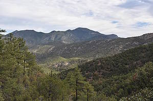
Azurite, Malachite and Donnellite by markthurman53  Overview OverviewEureka Canyon is a small side canyon of the larger Sunnyside Canyon. The Sunnyside Canyon Trail is a part of the Arizona Trail and is, therefore, more familiar to most. Eureka Canyon Trail follows along the ridge just west of Eureka Canyon and eventually along the ridge to the west of Sunnyside Canyon before hooking back up with the Sunnyside Canyon Trail. The Eureka Canyon Trail follows an old 2 track for the first half of the 3.5 miles to the area of the Eureka mine. Further up the Trail is the Copper Glance Mine. Eureka and Sunnyside Canyons have a history that dates back to 1890 when a preacher named Sam Donnelly founded a town there called Sunnyside. Sam Donnelly was a reformed drunk and fighter turned preacher. The community at its peak had about 80 people and they were called Donnellites by outsiders. They came to hear him preach and work the nearby mines. This was a mining town without bars or brothels. The town faded into history when Sam Died in 1903. The townsite is still on private property but you can visit the ghost town. The Eureka and Copper Glance mines were two of the mines operated out of Sunnyside. The area history and the story of Sam Donnelly are very interesting and rather than get into all the details here, it is worth reading the history online. Bruce A Peterson “Sky Island Righteousness above a desert of sin: “Donnellite” Seeds in Sunnyside Canyon”.
The Eureka Trail Head is along the Sunnyside Canyon Trail on the Sunnyside Canyon Forest Service Road. The first 0.5 miles is along the Sunnyside Canyon Trail, also part of the Arizona Trail. When the trail crosses Sunnyside Creek look to the right (south), there is an old 2 track that heads uphill, this is the trailhead for the Eureka Canyon Trail. There is a sign indicating you are entering Miller Peak Wilderness at this point. A tenth of a mile in along this road is a sign calling out the Eureka Canyon Trail #129. From this sign, it is 3.5 miles to the junction with the upper end of the Sunnyside Canyon Trail and 4.7 to the Crest Trail. For a Trail named Eureka Canyon Trail, it spends zero time in a canyon, this is a ridge trail. The trail has a steady climb to the junction with the Sunnyside Canyon Trail. A couple of places along the ridge it levels out for short stretches. At 1.3 miles in the trail leaves the road and heads uphill toward Eureka Peak. A rock cairn marks this spot. The old road continues to where the map labels the Eureka Mine. I didn’t go there so I’m not sure what is there. The trail passes just below Eureka Peak where there appears to be an old mine, probably part of the Eureka mine that is just below this point. The ground is covered with light blue and green copper minerals, azurite, and malachite. From what I have heard this area has been picked over by rock hounds so probably not a lot of great samples lying around. The views to the north along this section are good, Huachuca Peak being the dominant peak. The trail continues in an upward direction to a saddle where it then just follows the ridgeline. The Copper Glance Mine is at 3.1 miles in. The mine itself is off to the south about 0.3 miles but there are the remains of a shack that was part of the Copper Glance operation. The Eureka Trail at the shack crosses another trail that heads off to the north and this is the Copper Glance Trail that heads down canyon to the Sunnyside Canyon Trail. The Eureka Trail heads uphill along the ridge; this is the steepest part of the trail. The trail here is paralleling just above the Sunnyside Canyon Trail and eventually connects up with it just below the switchbacks. The Eureka Canyon Trail is easy to follow even though it appears to be seldom used. While this trail is a way up to the Crest Trail most use the Sunnyside Canyon Trail. Unless your intentions are visiting the mines it is easier to take the Sunnyside Canyon Trail. There are nicer views along the Eureka Trail but if you are heading up to the crest you can wait until you get up there for the views, they won’t change in the time it takes you to get there. Check out the Official Route and Triplogs. Leave No Trace and +Add a Triplog after your hike to support this local community. One-Way Notice This hike is listed as One-Way. When hiking several trails on a single "hike", log it with a generic name that describes the hike. Then link the trails traveled, check out the example. | ||||||||||||||||||||||||||||||||||||||||||||||||||||||||||||||||||||||||||||||||||||||||||||


