 Route Editor

| Guide | ♦ | 1 Triplog | 0 Topics |
details | drive | permit | forecast | 🔥 route |
stats |
photos | triplog | topics | location |
| 12 | 1 | 0 |
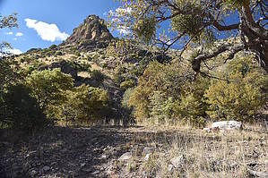
Mine with a spring by markthurman53  Overview OverviewThe Copper Canyon Trail is along the Montezuma Canyon Road 1.3 miles from Montezuma Pass. The trail is actually a jeep trail. This can be taken with a 4WD high clearance but come on, it’s only 0.9 miles. Get out and take a walk up a really scenic Canyon with a bit of mining history. At about 0.8 miles up this steep road is a mine filled with water, the source of a spring. On the return trip, 0.2 miles from the trailhead, take a side canyon that comes into Copper Canyon from the north. Oak Spring is 0.1 miles up this side Canyon. There are some really large sycamore and oak trees in this canyon. Hike The trailhead is on the south side of Copper Canyon, where Montezuma Canyon Road crosses the creek. There is a large parking area for more cars than I think would ever be needed for this trail. Across the road is a jeep trail that goes up Copper Canyon. From the amount of rocks and debris, this canyon appears to get very large volumes of water coming down it from time to time. The trail continues upstream and gets rather steep, as many jeep trails do. Unlike most hiking trails, Jeep trails see where they want to be and just head straight up. This trail gains most of the 600 feet in just 0.7 miles. The rock foundation of some kind of structure is on the right side of the trail, about 0.4 miles in. At 0.8 miles in, a mine is filled with water on the left side of the trail. Apparently, this mine has tapped into a spring, and the water flows out of the mine over a small drop-off into the creek. The Geology in this area is fascinating, another area where Limestone butts up against sedimentary rocks along a fault. While at the mine, look up into the large pine tree, and there is a chair tied to the tree, looks like a blind used to hunt unsuspecting deer. All it needs is a fridge and maybe a TV.
Check out the Official Route and Triplog. Leave No Trace and +Add a Triplog after your hike to support this local community. One-Way Notice This hike is listed as One-Way. When hiking several trails on a single "hike", log it with a generic name that describes the hike. Then link the trails traveled, check out the example. | ||||||||||||||||||||||||||||||||||||||||||||||||||||||||||||||||||||||||||||||||||||||||||||||||||||||||


