 Route Editor

| Guide | ♦ | 5 Triplogs | 1 Topic |
details | drive | permit | forecast | route |
stats |
photos | triplogs | topic | location |
| 43 | 5 | 1 |
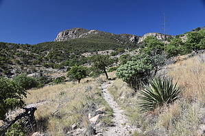
Carr to Miller Low Down by markthurman53   Overview OverviewThe Perimeter Trail connects lower Car Canyon to lower Miller Canyon. This trail does a little climbing from either Miller or Carr Canyon trailheads and then follows along the base of the Huachuca Mountains overlooking Sierra Vista. There are endless views to the east from the south to the north. Mountain ranges insight are the Whetstones to the north, and across the San Pedro River Valley, the Dragoons and Tombstone Mountains with the Chiricahua in the distance. This is not a real exciting trail since it parallels the hillside below Carr Peak, so timing is essential to make the most out of this hike. Late winter and early spring are the best times to turn this hike into a real gem. The wildflowers, stream crossings, and views would be best at this time. There are no connecting trails, so it is hard to turn it into a loop hike, although not directly connecting, the Clark Spring, John Cooper Trail could be used to make a loop. This loop would also take you through the Carr House historical site. Hike This guide is from the Carr Canyon trailhead. The trail starts on the east side of the parking lot, where a sign for the Perimeter Trail #138 states that Miller Canyon Road is 3.7 miles. Almost immediately, the trail crosses Carr Canyon Creek. Within a tenth of a mile, another sign again indicates the Perimeter Trail and points out the Carr House Nature Trail. The trail does a 120-foot climb in the first 0.3 miles then shortly after another 200-foot climb. This is the high point on the trail (elevation wise, not interest). The vegetation is Oak, Juniper, and grassland, switching from time to time. There are about a half dozen small side canyons along this trail, and at these points, the trail has a little bit of elevation change, nothing too much, though. Miller Canyon trailhead is about 100 feet lower than Carr Canyon, so there is more uphill from Miller Canon, but it is only 100 feet. This trail is in good condition and appears to be used by mountain bikers also. There are great views from all along this trail, unlike some trails where you have to wait for clear, unobstructed views; this trail has them almost continuously. The downside to this trail is that the last half toward Miller Canyon, the sound of traffic on Highway 92, is virtually constant. Not until you drop into Miller Canyon does that background noise disappear. I do think the key to keeping this trail from just being a blah trail that goes from Point A to Point B is timing. Pick a day where the air is clear, plants blooming, and temperatures below the mid-70s. It might even be a great evening hike. Check out the Official Route and Triplogs. Leave No Trace and +Add a Triplog after your hike to support this local community. One-Way Notice This hike is listed as One-Way. When hiking several trails on a single "hike", log it with a generic name that describes the hike. Then link the trails traveled, check out the example. | ||||||||||||||||||||||||||||||||||||||||||||||||||||||||||||||||||||||||||||||||||||||||||||


