 Route Editor

| Guide | ♦ | 2 Triplogs | 0 Topics |
details | drive | permit | forecast | 🔥 route |
stats |
photos | triplogs | topics | location |
| 0 | 2 | 0 |
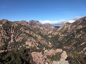
  Overview OverviewOff-trail hike to a minor summit separating the South Fork of Cave Creek from Log Canyon, providing a rather remarkable view of the surrounding area. This hike involves about 3 miles (one way) of official, numbered trails followed by a quarter-mile-or-so bushwack to the summit. On some topo maps, this peak is labeled 6415. On others, it is Log Peak. I'm not sure if this is the official name, but I've seen the canyon on the east side referred to as "Log Canyon", and said canyon has Log Spring.
The easiest access to this peak is South Fork Trailhead. It's possible to access this from the south end of Burro Trail via Horseshoe Canyon, but it would be far less convenient. Head up South Fork trail about 2 miles to the junction of Burro Trail. In times of heavy flow, the south fork of Cave Creek may be difficult to cross (you can bypass the first four crossings by staying on the west side of the creek, and the fifth can be avoided by walking across a log). Burro Trail aggressively climbs out of the South Fork drainage. Stay on Burro Trail for about three-quarters of a mile until you hit the crest of the ridge separating South Fork from Log Canyon. Once you hit the ridge, leave the trail, heading north. It's a pretty straightforward bushwack. Just head north, and try to avoid the sharp stuff as much as possible. There is a hundred feet or so where you have no choice but to force your way through some thick vegetation but follow the path of least resistance. Along the way, there are some excellent views down into a narrow part of Log Canyon, where, when the water is flowing, you can hear cascades far below. Once you're at the summit, you'll find some sort of solar-powered data gathering station (couldn't figure out exactly what it was for), and you'll be treated to some incredible views of the South Fork and Log Canyon. You can also see the Chiricahua Crest off in the distance, and looking up the east fork of Log Canyon, there are a lot of the hoodoos that are characteristic of the area. Check out the Official Route and Triplogs. Leave No Trace and +Add a Triplog after your hike to support this local community. One-Way Notice This hike is listed as One-Way. When hiking several trails on a single "hike", log it with a generic name that describes the hike. Then link the trails traveled, check out the example. | ||||||||||||||||||||||||||||||||||||||||||||||||||||||||||||||||||||||||||||||||||||||||||||||||||||||


