 Route Editor

| Guide | ♦ | 11 Triplogs | 0 Topics |
details | drive | no permit | forecast | route |
stats |
photos | triplogs | topics | location |
| 56 | 11 | 0 |
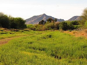
Canals, sidewalks, berms, and a wash by DarthStiller  Overview OverviewThis section of the Maricopa Trail is a 20+ mile spur that branches off from the main loop and connects it to San Tan Mountian Regional Park, to the southeast. It branches off from the main loop across from Freestone Park on Lindsay Road. Park in Freestone Park at the first parking lot, and walk across the field/detention basin, and up the hill to the sidewalk. At the junction, there is a map kiosk of the Maricopa Trail showing your location and the nearby sections of the trail. Trail This section begins to follow a section of the Consolidated Canal to the southwest, which is also part of the East Valley segment of the trail. This section is 5.3 miles long and goes through mainly residential areas. There is an intersection crossing at Gilbert and Warner involving a lot of traffic, after that it’s back in the neighborhoods. Some bigger yards have farm-related activity interspersed with manicured subdivisions and apartment complexes. At the crossing with Chandler Boulevard, there is currently an empty field that looks like it is slated for future development, which could be either residential or commercial. The trail in this section is always either paved or concrete, but there is usually a wide enough landscaped area off to the side if you prefer to walk on a slightly more natural surface. This section of this segment is also maintained as trail systems for Chandler & Gilbert and is also part of the Heritage Trail. Map kiosks for those trail systems are also posted along here, as well as some very pedestrian bridges to allow easy crossing. South of the Warner/Gilbert intersection, the trail seems to be officially on either side of the canal.
At Higley Road, the trail heads directly south for about 2 miles to Queen Creek Road. Most of this is also sidewalk, but there is a nice 0.7 mi section where a pea gravel biking/walking path parallels the sidewalk. The crossing of the Roosevelt Conservation District Canal gives the best views along Higley. The trail follows the east side of Higley. Eastbound again along Queen Creek Road, things get slightly better just past the plaza on the southeast corner of Higley and Queen Creek. More landscaping is available to get away from the sidewalk. At first, it’s a berm of a drainage canal, then some more gravel that is shaded with Palo Verdes. The trail follows the south side of Queen Creek Road for 2 miles. Just before Power Road, the trail cuts behind a plaza and heads under the bridge into the wash. After crossing under Power, cross the wash again to the south side and follow that path. There are walking/biking paths on either side of the wash and are maintained by Queen Creek as part of their trail system. At the east end just at Sossaman Road, there is an MT marker indicating that the MT is officially on the south side of the wash. More markers seem necessary in this area. This segment is much nicer than the previous 10 miles of sidewalks in heavily developed areas, but it’s still paved and/or concrete. As of April 2020, a large subdivision is being built on the east end along Sossaman Road. The trail then heads south for just under two miles along the west side of Sossaman Road. The first half mile is a sidewalk, then it fades away as it passes two large farms. The views across the fields aren’t bad. Looking to the north, Red Mountain and the McDowells are very easy to spot, although very distant. Just before the Desert Wells historical monument, the trail heads into Sonoqui Wash and heads southeast. The official MT is paved and higher up along the banks and berms, but there is also a dirt path available lower in the wash intended mainly for equestrians. The lower dirt path offers nicer views of the vegetation (and less of the surrounding neighborhoods) and some solitude from other walkers, runners, and bikers. Following Sonoqui Wash will take you off the main segment of this trail to another spur that goes to Horseshoe Park for equestrians. If you leave the wash, you stay on the main trail southbound on Hawes Road. The trail follows the east side of Hawes until the crossing with the Hunt Highway, then it crosses to the west side. Most of this is along graveled berms that aren’t all that comfortable to walk on. After crossing the Hunt Highway, the trail begins its only real ascent as Hawes Road turns into Wild Horse Drive. Turn right on Sun Dance, left on Wagon Wheel, then right again on Skyline, and end up at the Goldmine Trailhead. There is no trail or even walking path to speak of at this time, but the views to the north are nicer as you gain elevation. Four Peaks and the Superstitions are very visible. To the south, San Tan Park is much closer and the trails inside the park are visible. Looking to the northwest, you can spot the Mormon Temple that’s at the midpoint of this section and see how far away that is, giving some idea of the length of this overall segment.
Check out the Official Route and Triplogs. Leave No Trace and +Add a Triplog after your hike to support this local community. One-Way Notice This hike is listed as One-Way. When hiking several trails on a single "hike", log it with a generic name that describes the hike. Then link the trails traveled, check out the example. | ||||||||||||||||||||||||||||||||||||||||||||||||||||||||||||||||||||||||||||||||||||||||||||||||||||


