 Route Editor

| Guide | ♦ | 39 Triplogs | 0 Topics |
details | drive | no permit | forecast | route |
stats |
photos | triplogs | topics | location |
| 101 | 39 | 0 |
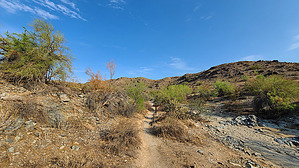
a decent alternative to the popular dirt road by joebartels  From Pima Canyon Trailhead, take the trail on the northside with the PC post. PC diagonals NW, 370 ft to the bottom of the sandy wash. Turn left and follow the right side of the wash. From Pima Canyon Trailhead, take the trail on the northside with the PC post. PC diagonals NW, 370 ft to the bottom of the sandy wash. Turn left and follow the right side of the wash.The tread is fine grain crushed rock, AKA course sand. You'll see a 4x4 steel post off to the right before "am I in the right place" sets in. A short-n-steep ascent takes you out of the wash at 0.17 miles. Soon you'll realize that you're paralleling the old dirt road the majority utilize.
Just as the fun begins, post 17 takes you out of the wash. It's pretty faded; no worries if you miss it because you're back near the wash very soon at post 18. Desert Ironwoods are nice in the low morning light as you cross over into the wash at post 19. By post 20, I thought this is a decent little Trail! It's sandy between posts 20 and 21. After post 21, you'll find the trail on a hard-packed apron to the right for a little segment. Back across the sand, post 22 is in the now broad wash. The wash bends back towards the road, and I could hear the coasting gear cassettes on ten-speed bikes above. Well, I guess 21 speed took over in the 90s. Imagine Z's and Alpha's roll their eyes and call 'em stupid... lol. By post 24, you're out of the wash, and there's a cement bench to the right. This last segment would be difficult for beginner mountain bikers. Geology-wise, this is the coolest part of the hike. You're isolated from the surrounding city now. 26 brings you back into the wash, and it's the deepest sand of the hike, a whopping 15-foot crossing. Shortly after 27 is the only questionable turn. Turn left to end at the National Trail. You'll see two posts and will soon notice another.
Check out the Official Route and Triplogs. Leave No Trace and +Add a Triplog after your hike to support this local community. One-Way Notice This hike is listed as One-Way. When hiking several trails on a single "hike", log it with a generic name that describes the hike. Then link the trails traveled, check out the example. | ||||||||||||||||||||||||||||||||||||||||||||||||||||||||||||||||||||||||||||||||||||||||||||||||||||||||||||||||||||||||||||||||||||||||||||||||||||||||||||||||||||||||||||||||||||||||


