username
X
password
register
for free!
help
 This is likely a great time to hike this trail!  Check out "Preferred" months below, keep in mind this is an estimate.
 

Bartlett Rock Art, UT

Guide 2 Triplogs  0 Topics
  3.5 of 5 
Fav
Wish
0
details
drive
no permit
forecast
map
stats
photos
triplogs
topics
location
20 2 0
HAZ reminds you to respect the ruins. Please read the Archaeological Resources Protection Act of 1979 & Ruins Etiquette
Statistics
tap icons for details
Difficulty 0.5 of 5
Route Finding 1 of 5
Distance Round Trip 1 mile
Trailhead Elevation 5,309 feet
Elevation Gain 130 feet
Accumulated Gain 130 feet
Avg Time Round Trip 1 hour
Kokopelli Seeds 1.65
 Interest Ruins, Historic & Seasonal Waterfall
 Backpack No
feature photo
Photos Viewed All MineFollowing
10  2022-10-04 AZLOT69
10  2020-03-01 PaleoRob
Author
author avatar Guides 172
Routes 229
Photos 6,096
Trips 1,129 map ( 2,527 miles )
Age 42 Male Gender
Location Pocatello, ID
Associated Areas
list map done
Southeast Region
Historical Weather
Trailhead Forecast
Expand Map
Preferred Apr, Oct, Mar, May
Seasons   Spring to Autumn
Sun  5:06am - 7:26pm
Route
 
0 Alternative
 
 Water


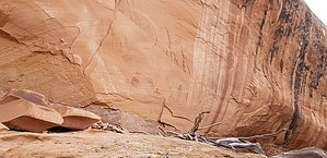
No barriers to this canyon's art
by PaleoRob

 Likely In-Season!
Overview
The Bartlett Rock Art site is a great way to see some Barrier Canyon style rock art without an arduous trek into the backcountry.


History
Painted several thousand years ago by the predecessors of today's Ute and Pueblo peoples, Barrier Canyon rock art is almost always painted and often much larger than life. The figures are often described as "haunting," and, "otherworldly," and many panels bear modern names that reflect this, such as The Holy Ghost Panel and The Comet Thrower.

This panel has seen heavy visitation since at least the 1950s, owing to its proximity to Moab. As a result, there has been some vandalism and numerous social trails leading to the site. Thankfully much of this damage has been mitigated in recent years. Please respect that hard work and help preserve this site for future generations.


Hike
The hike itself is fairly short (roughly a quarter mile) but it can be extended by further exploration along the ridge. Furthermore, if one has a low-clearance vehicle the hike becomes longer - about a mile and a half round-trip from the turnoff on BLM Road 137.

From the parking area, the rock art is clearly visible in the massive, north-facing alcove directly to the south. Read the orientation kiosk and then follow the trail to the left. There are still scars from numerous social trails that cross the dirt directly between the parking area and the alcove. Instead of continuing to damage that area, stay on the slickrock. You will contour around the east side of the basin. When snow is melting or after a rainstorm, the slickrock at the entrance of the alcove can be the bottom of a waterfall, so be cautious - this also means ice forms readily on this slope when it is colder. Watch your footing!


The best views of the art are probably from the base of the alcove fill, but you can climb up for a closer look. There is also a seep and some neat relic vegetation (pines, etc.) in the alcove. If you brought pets with you, don't allow them up into the alcove fill (as with any other archaeological site) and remember not to touch, trace, or otherwise mark on the fragile sandstone surface.

Once you've explored the alcove and seen your fill of the rock art, return to your vehicle the way you came.

Water Sources
A small seep, but bring your own.

Camping
Camping is available in nearby established campsites but this location is closed to camping.

Check out the Triplogs.

Leave No Trace and +Add a Triplog after your hike to support this local community.

2020-05-07 PaleoRob
    WARNING! Hiking and outdoor related sports can be dangerous. Be responsible and prepare for the trip. Study the area you are entering and plan accordingly. Dress for the current and unexpected weather changes. Take plenty of water. Never go alone. Make an itinerary with your plan(s), route(s), destination(s) and expected return time. Give your itinerary to trusted family and/or friends.

     Permit $$
    None


     Directions
    or
    or
     Road
    FR / Jeep Road - Car possible when dry

    To hike
    From Moab, drive north on Highway 191 to the 313 highway turnoff (at the Moab Giants Museum). Turn left (your only option) and follow 313 through the canyon and up onto a series of ridges. Past the Navajo Rocks trailhead, there is a signed turnoff on the right for the Lone Mesa Campground at ~8.4 miles. This is the Dubinky Well Road, also marked as BLM Road 137 on some maps. Follow this road, which is a good gravel road, for 0.8 miles. In the middle of a meadow, past the campgrounds, there will be a dirt two-track that heads left (southwest) towards a bluff. This is the Bartlett Rock Art turnoff. There is no sign for the rock art but there is a day-use only sign at the turnoff. Low-clearance vehicles should park here and hike in along the road. Medium- and high-clearance vehicles can make it to the trailhead itself, which is about a half-mile down the track. There are a couple of sandy spots and two rocky areas to cross before reaching the slickrock parking area at the trailhead.
    page created by PaleoRob on May 07 2020 1:25 pm
     90+° 8am - 6pm kills
    Avoid Heat Illness - stay cool
    helpcorrectionissue

    end of page marker