 Route Editor

| Guide | ♦ | 4 Triplogs | 0 Topics |
details | drive | no permit | forecast | route |
stats |
photos | triplogs | topics | location |
| 39 | 4 | 0 |
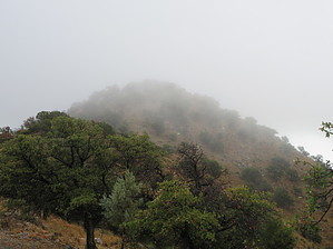
Win, Placer, or Show by DixieFlyer  Overview OverviewPlacer Peak (elevation of 5,940' and prominence of 160') is in the Sierrita Mountains, about 40 miles SW of Tucson. Those hiking Placer Peak generally do so in conjunction with hiking Keystone Peak, which is the highest peak in the Sierrita Range. History The hike is in an area known as the McGee Ranch Settlement.
The current size of the Ranch is about 19,200 acres. The ranch's original size was more extensive, but a portion was sold to the Duval Sierrita Corporation in 1960 when the Duval Mine was developed. As the name Placer Peak suggests, the area has a rich mining history. However, over the years, construction, hauling, and ranching have been the principal occupations. Those interested in reading more about the history of the McGee Ranch Settlement may wish to review this article from the Green Valley Recreation Hiking Club. Hike The trailhead is a small parking area next to a water tank on McGee Ranch Road. The hike begins on a well-graded dirt road that goes up to Keystone Peak. The road on the initial part of the hike is fairly level, and you'll pass by some buildings and an old family cemetery. Not too far past the cemetery, the road begins to climb, but the grade is not very severe. About 2.5 miles or so into the hike, you'll pass the West Star Cabin, built in 1912. About 1/2 mile past the cabin you'll see a trail on the left side of the road(GPS coordinates of 31.88292, -111.20918). This trail goes up to Placer Peak. There is an electric fence that you have to step over when leaving the road. Follow the trail for about 0.3 miles up to the summit of Placer Peak. The initial part of the trail is about 5 feet wide, but it narrows slightly near the summit. There are no trees at the summit, so you have some nice, unobstructed views. I did not see a benchmark disc, but there is an iron pin driven into the ground at the summit. After spending time at the summit, you can reverse the course and return to the trailhead. However, most hikers will want to continue on the road up to Keystone Peak. Red Tape The hike takes place on private property, much of which is part of the McGee Ranch Settlement. Access is given to hikers and others who want to enjoy the area. Please be respectful and follow leave-no-place principles to help ensure that this access continues. Check out the Official Route and Triplogs. Leave No Trace and +Add a Triplog after your hike to support this local community. One-Way Notice This hike is listed as One-Way. When hiking several trails on a single "hike", log it with a generic name that describes the hike. Then link the trails traveled, check out the example. | |||||||||||||||||||||||||||||||||||||||||||||||||||||||||||||||||||||||||||||||||||||||||||


