Route Editor

| Guide | ♦ | 15 Triplogs | 0 Topics |
details | drive | permit | forecast | 🔥 route |
stats |
photos | triplogs | topics | location |
| 221 | 15 | 0 |
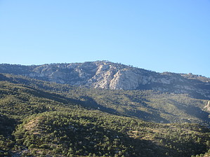
  Overview OverviewMica Mountain has an elevation of 8,664' and a prominence of 4,608'. It is part of the Rincon Mountain range, and it is in Saguaro National Park, east of Tucson. Mica Mountain is the high point of the range and the Park. In terms of prominence, Mica Mountain is the 7th most prominent peak in Arizona and the 77th most prominent peak in the continental United States. Hike The summit of Mica Mountain is just a few feet off of the northern section of the Fire Loop Trail. You'll see some concrete footings used for a fire lookout tower that was once at the summit. Mica Mountain is a flattish summit with lots of sparse ponderosa pines; thus, there are no panoramic 360-degree views at the summit. For that reason, many hikers will hike about 1/2 mile to Spud Rock. Spud Rock is about 50 feet lower than Mica Mountain, but there are no trees around it, resulting in fabulous views.
There are at least three routes used to hike to Mica Mountain: 1) Begin hiking from the Turkey Creek Trailhead on Turkey Creek Trail #34. While this is the shortest route to Mica Mountain, it is still 17 miles long, with around 4,700 feet of elevation gain. A high clearance 4WD vehicle will be needed to drive the last couple of miles to the trailhead. 2) Drive through Redington Pass and use Italian Spring Trail #95 as a springboard to get to Mica Mountain. You'll need a high clearance 4WD vehicle to get to the TH, and the hike will be on the order of 20 miles in length with 5,000 feet of elevation gain. 3) Drive to the far eastern end of Speedway Road in Tucson and begin hiking on the Douglas Spring Trail. While the road to the trailhead is paved all the way, a hike to Mica Mountain on this route would be 26 miles in length; as such, it is much more popular with backpackers than day hikers. Synopsis Mica Mountain is a nice peak to summit, although there is no quick way to get there. For that reason, it is more popular with backpackers than day hikers. While a day hike is doable, it is suitable only for a fit hiker.
Check out the Official Route and Triplogs. Note This is a difficult hike. It would be insane to attempt this entire hike without prior experience hiking. Leave No Trace and +Add a Triplog after your hike to support this local community. | ||||||||||||||||||||||||||||||||||||||||||||||||||||||||||||||||||||||||||||||||||||||||||||||||||||||||||||||||||||||||||||||||||||||||||||||||||||||||||||||||||||||||||||||||||||||||||||||||||||||||||||||||||||||||||||||||||