dotted vegetation with stretching views by HAZ_Hikebot
This trail provides an access route into the eastern portion of the Saguaro National Park. It is part of the Arizona Trail, a national scenic trail that spans the entire state from north to south.
The portion of the Turkey Creek Trail in the Coronado National Forest follows a ridge that separates Turkey Creek and Mesquite canyons. Part of this section of the trail is within the boundaries of the Rincon Mountain Wilderness. The landscape through which it passes is similar to that of the Saguaro National Park, dotted with large saguaros and other vegetation characteristics of the Sonoran Desert. Views stretch to Rincon Peak on the south and the Santa Catalinas to the north.
Saguaro National Park restrictions: No hunting, weapons, pets, or bicycles. Camping in designated areas only. Must have a wilderness permit, which is available at the Park Visitor Center.
Nearby History Spud Rock - Outstanding point of bare rock in plain view from Tucson at the north end of the Rincons, elevation 8,590 feet. About 24 miles east of Tucson. George F. Kitt of Tucson says: "Two Southern Pacific railroad engineers, William H. Barnett and Jim Miller, had a shack here and raised potatoes and cabbage on a little flat close to the rock. They called it Spud Rock for their major crop --spuds. Barnett fell from his horse one day coming down the trail and was killed."
When hiking several trails on a single "hike", log it with a generic name that describes the hike. Then link the trails traveled, check out the example.
WARNING! Hiking and outdoor related sports can be dangerous. Be responsible and prepare for the trip. Study the area you are entering and plan accordingly. Dress for the current and unexpected weather changes. Take plenty of water. Never go alone. Make an itinerary with your plan(s), route(s), destination(s) and expected return time. Give your itinerary to trusted family and/or friends.
Permit $$
See Forest Service Data Above
Coronado Forest MVUMs are rarely necessary to review unless mentioned in the description or directions Coronado Motor Vehicle Use Maps (MVUMs)
Saguaro National Park 2022 $25 vehicle • $20 motorcycle • $15 individual on foot or bicycle
Receipt is valid for 7 days
$45 Annual Park Pass View All
No fee required from Miller Creek Trailhead off Mescal Rd.
Directions
Road
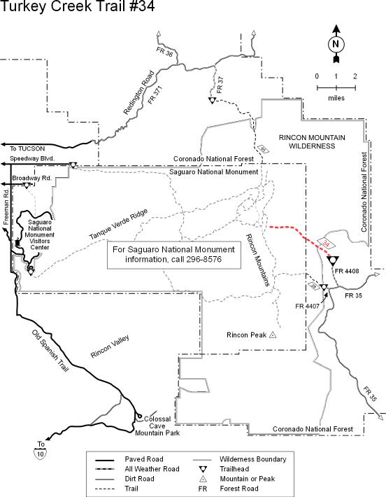
To hike Drive east 39 miles from Tucson on Interstate 10 to the J-Six-Mescal road exit (#297). Turn north on the Mescal Road and continue 16.4 miles to FR 4408. Turn left and travel 0.4 miles through a gate to a parking area with large sycamore trees. The trail starts on the opposite side of the creek and follows a 4-wheel drive road 1.5 miles to the single track.
 Route Editor


 This trail provides an access route into the eastern portion of the Saguaro National Park. It is part of the Arizona Trail, a national scenic trail that spans the entire state from north to south.
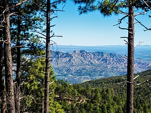


