username
X
password
register
for free!
help


Mount Fagan Bike-Hike via AZ83, AZ

Guide 1 Triplog  1 Topic
  5 of 5  
Fav
Wish
0
details
drive
permit
forecast
route  
stats
photos
triplog
topic
location
0 1 1
Statistics
tap row or icons for details
Difficulty 3.5 of 5
Route Finding 2 of 5
Distance Round Trip 10 miles
Trailhead Elevation 4,000 feet
Elevation Gain 2,185 feet
Accumulated Gain 2,287 feet
Avg Time Round Trip 3-4 hours
Kokopelli Seeds 21.44
 Interest Peak
 Backpack Possible - Not Popular
Post the 1st photoset!
Author
author avatar Guides 1
Routes 1
Photos 0
Trips 1 map ( 9 miles )
Age 72 Male Gender
Location Vail, AZ
Co-Author
co-author avatarGuides 16,843
Routes 17,472
Photos 24
Trips 1 map (6 Miles)
Age 28 Male Gender
Location HAZ, TrailDEX
Associated Areas
list map done
Tucson Region
Historical Weather
Trailhead Forecast
Radar Map
Expand Map
Preferred Nov, Feb, Mar, Apr
Seasons   Autumn to Spring
Sun  6:00am - 6:43pm
Official Route
 
0 Alternative


When in Vail...
by rvanremo & HAZ_Hikebot

 
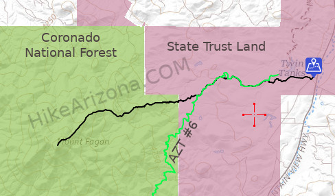
Mount Fagan Bike-Hike is a very pleasant, thoroughly rewarding, and occasionally challenging through mesquite, oak & grassland habitats with mariposa lily blooms in springtime. The views from ridgelines and peaks in this area are stellar.


Bike-Hike
Initially, mtn-bike recommended, it roughly parallels the road to The Lake from AZ83, skirting two rough sections of the doubletrack with adjacent singletrack segments. Eventually merging with the SW-bound Las Colinas - AZT #6 from about 0.8 to 2.2 miles. The exception is a peculiar 0.25-mile for a 30-ft gain, lazy switchback on the AZT.
remove free decal offer
Then branch westbound, following a path that offers several trailside options for caching your mtn-bike, such as 31.9037, -110.6952. Continuing on foot leads hikers across a canyon and through the hills to a forked junction (31.9012, -110.7085) with two distinct route choices: Peak 5102 (nearer) or Mt. Fagan (farther).

The Mt. Fagan route traverses a contour around the S flank of Peak 5102, then ascends steadily on various wildlife paths to a primary ridgeline that leads to the summit of Mt. Fagan (6189' elev). This route is not for the faint of heart as it will give you a solid workout, and there are several technical pitches and storm-groomed slopes that require your full attention. This bike-hike is wholly within AZ State Lands and the Coronado NF and is subject to those agencies' regulations.
( view permits )

2020-12-04 rvanremo & HAZ_Hikebot
  • Fagan Bike-Hike
    guide related
    Fagan Bike-Hike


Check out the Official Route and Triplog.
Leave No Trace and +Add a Triplog after your hike to support this local community.
WARNING! Hiking and outdoor related sports can be dangerous. Be responsible and prepare for the trip. Study the area you are entering and plan accordingly. Dress for the current and unexpected weather changes. Take plenty of water. Never go alone. Make an itinerary with your plan(s), route(s), destination(s) and expected return time. Give your itinerary to trusted family and/or friends.

 Permit $$
AZ State Recreational Land Permits
For hiking, driving & sightseeing purposes, you seek a recreational permit.
Under "Recreational Land Use" in the link above.
2022 - $15.00 individual
2022 - $20.00 family limited to two adults and children under the age of 18
Plus $1 processing fee
The permitting process is quick, you will be emailed your permit instantly.

Land Parcel Map


 Directions
or
 Road
Paved - Car Okay

To hike
I-10 to AZ83 S-bound up Davidson Cyn, then right turn onto The Lakes Rd (dirt), go through gate to parking area
page created by rvanremo on Dec 04 2020 9:59 am
 90+° 8am - 6pm kills
helpcorrectionissue

end of page marker