 Route Editor

| Guide | ♦ | 1 Triplog | 0 Topics |
details | drive | permit | forecast | 🔥 route |
stats |
photos | triplog | topics | location |
| 0 | 1 | 0 |
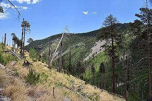
Chiricahua Largest Spring by markthurman53   CHIRICAHUA MOUNTAINS CHIRICAHUA MOUNTAINSThe Chiricahua Mountains are located in far southeast Arizona on the New Mexico and Mexico border. This mountain is probably the remotest of the over 9000 feet high sky island ranges. The closest towns are Wilcox, 40 miles to the north, and Douglas, about the same to the south. No paved roads enter this range except a short portion on the east side of the range near Portal, Arizona, and there isn’t any easy way to get there. One dirt road traverses the range from the west side near the Chiricahua Monument and ends at Portal. The remoteness makes for great hiking if you prefer solitude. Many of the trails are in poor condition with a few exceptions, ravaged by the Rattlesnake fire in 1994 and the Horseshoe 2 fire of 2011. If you are into route finding, then this is the place to hike. OJO AGUA FRIA TRAIL #361
The Ojo Agua Fria Trail #361 is located on the upper reaches of Cave Creek just below the Chiricahua Crest and east of Chiricahua Peak at Aspen Saddle. This spring is the largest flowing spring in the Chiricahua Mountains. This area was devastated by the Horseshoe 2 fire in 2011, so the landscape is barren of trees, with a few dead trees still standing and the rest lying in disorder on the ground. The Aspen trees are coming in on the upper hills along the crest and are quite scenic despite all the fire damage. Description From the Crest Trail #270C at Aspen Saddle, the Ojo Agua Fria Spring Trail heads east down the upper reaches of Cave Creek Canyon. At the Trail Junction with the Crest Trail, there is a sign for the Ojo Agua Fria Trail, but it is in pretty sad shape lying on the ground. The trail heads east, and at about 0.1 miles in is a sign pointing to the north for the Headquarter Spring Trail #362 and another sign pointing south for the Ojo Agua Fria Trail #361. From this sign, the trail heads downhill steeply through a lot of small trees brush and deadfall. The trail can be a little vague in places. After going 400 feet, the trail turns to the east (watch for this turn; I missed it at first) and continues in this direction for about 0.4 miles. The trail does a switchback and heads back southwest to the spring. (The official GPS route does not show this final 0.1-mile descent to the spring). The grade is steep all along this trail because you have to drop 600 feet in 0.7 miles. This trail is pretty vague, and if the grasses are growing, the trail might be hard to find. I had to keep a good eye out for the trail in June, and there wasn’t much growth. At the Spring, there is a metal tank that may or may not have water in it depending on the condition of the hose that feeds the tank from the Spring. The spring itself is about 50 feet up the hill to the southwest. Check out the Official Route and Triplog. Leave No Trace and +Add a Triplog after your hike to support this local community. One-Way Notice This hike is listed as One-Way. When hiking several trails on a single "hike", log it with a generic name that describes the hike. Then link the trails traveled, check out the example. | ||||||||||||||||||||||||||||||||||||||||||||||||||||||||||||||||||||||||||||||||||||||||||||||||||||||


