 Route Editor

| Guide | ♦ | 1 Triplog | 0 Topics |
details | drive | permit | forecast | 🔥 route |
stats |
photos | triplog | topics | location |
| 0 | 1 | 0 |
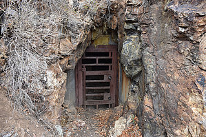
See the cave but don't go in by markthurman53   CHIRICAHUA MOUNTAINS CHIRICAHUA MOUNTAINSThe Chiricahua Mountains are located in far southeast Arizona on the New Mexico and Mexico border. This mountain is probably the remotest of the over 9000 feet high sky island ranges. The closest towns are Wilcox, 40 miles to the north, and Douglas, about the same to the south. No paved roads enter this range except a short portion on the east side of the range near Portal, Arizona, and there isn’t any easy way to get there. One dirt road traverses the range from the west side near the Chiricahua Monument and ends at Portal. The remoteness makes for great hiking if you prefer solitude. Many of the trails are in poor condition with a few exceptions, ravaged by the Rattlesnake fire in 1994 and the Horseshoe 2 fire of 2011. If you are into route finding, then this is the place to hike. CRYSTAL CAVE TRAIL #382
Chiricahua Crystal Cave is one of the most unique recreational attractions in the Douglas Ranger District. It is a moderately large cave (2.38 miles total passage) that is primarily horizontal, with a handful of drops less than 20 feet deep. Within the cave, twisting tunnels and narrow passages extend in all directions: vertically, horizontally, and diagonally. The geologic features of Crystal Cave are truly spectacular. To preserve the beauty of this unique resource, which tragically has been damaged by vandals, the cave is protected by a locked gate. A key to the gate is available from the Douglas Ranger Station, and from US Forest Service-approved keyholders, with an approved permit and a $100.00 deposit. No access to the cave is permitted from April 15 to October 15, while a maternity colony of Townsend’s big-eared bats is using the cave to raise their young. Visitors must be properly equipped and ready to take the necessary precautions to protect both themselves and the fragile cave environment. Overview The Crystal Cave trail is located along the Heb Martyr Road FR42A along a normally dry creek that comes down off of Centella Ridge. This is one of those trails you take because you have a curiosity for what is at the end and not because of the scenery and views or for some to get a workout. This trail is only 0.3 miles long and is extremely flat for 0.2 miles, then steep for the last .1 miles. At the end is Crystal Cave, Which is locked. After you are done staring at the locked door, turn around and check out the view of the entire Cave Creek Basin (so I lied there is one good View). For those who are planning on entering the cave, go to the forest service website for Crystal Cave to see what the process is. Description The trailhead for the Cave Creek Trail is 0.6 miles in on Herb Martyr Road 42A. There are two trails at this spot. To the left of the road (southeast) is the Snowshed Connector Trail #246A with a sign labeled as the Snowshed Basin Trail. To the right of the road (northwest) is the unsigned Crystal Cave Trail #382. The trail starts on the east side of a rock wall that I guess is protecting the road from washouts. The trail heads up the unnamed creek (some call it Crystal Creek) alongside the rock retaining wall for about 100 yards before exiting the creek to the right. There is a sign at the exit point, but whatever was posted on it is gone. From here, the trail is flat and heads through an oak, pinion pine, and juniper forest. At about 0.2 miles in, the trail crosses the creek and climbs about 50 feet to avoid a 10-foot waterfall in the creek. The trail along this section above the falls is a little washed out but still easy to follow. The waterfall in the creek is worth checking out because of the folds in the rock. Once past the waterfall obstruction, the trail drops back into the creek, where it crosses immediately to the north side and begins a pretty aggressive climb to the cave. At the creek, a sign indicates that Crystal Cave is closed to the public. This climb from the creek to the cave is about 0.1 miles. The cave itself is closed with an Iron door that requires a key to enter (See notes from Forest Service above). A sign just outside the entrance can no longer be read. If this is your destination and you aren’t going in the cave, take a moment to enjoy the view of all of Cave Creek Basin, so you won’t feel you totally wasted your time doing this trail. Gate Policy: If a gate is closed upon arrival, leave it closed after you go through. If it is open, leave it open. Leaving a closed gate open may put cattle in danger. Closing an open gate may cut them off from water. Please be respectful, leave gates as found. The exception is signage on the gate directing you otherwise. Check out the Official Route and Triplog. Leave No Trace and +Add a Triplog after your hike to support this local community. One-Way Notice This hike is listed as One-Way. When hiking several trails on a single "hike", log it with a generic name that describes the hike. Then link the trails traveled, check out the example. | ||||||||||||||||||||||||||||||||||||||||||||||||||||||||||||||||||||||||||||||||||||||||||||||||||||||||


