 Route Editor

| Guide | ♦ | 1 Triplog | 0 Topics |
details | drive | permit | forecast | 🔥 route |
stats |
photos | triplog | topics | location |
| 0 | 1 | 0 |
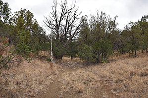
Crossover Trail With a History by markthurman53   CHIRICAHUA MOUNTAINS CHIRICAHUA MOUNTAINSThe Chiricahua Mountains are located in far southeast Arizona on the New Mexico and Mexico border. This mountain is probably the remotest of the over 9000 feet high sky island ranges. The closest towns are Wilcox, 40 miles to the north, and Douglas, about the same to the south. No paved roads enter this range except a short portion on the east side of the range near Portal, Arizona, and there isn’t any easy way to get there. One dirt road traverses the range from the west side near the Chiricahua Monument and ends at Portal. The remoteness makes for great hiking if you prefer solitude. Many of the trails are in poor condition with a few exceptions, ravaged by the Rattlesnake fire in 1994 and the Horseshoe 2 fire of 2011. If you are into route finding, then this is the place to hike. WASHBURN CANYON
The Washburn Trail is not a Forest Service numbered trail; historically, this route was used by Stephen Reed to transport goods between his homestead (now the Southwestern Research Station) and the town of Paradise. From the south, the trail starts at a corral along the North Fork of Cave Creek on FR42, 1.2 miles north of The Herb Martyr Road FR42A. The trail heads up Washburn Canyon to a saddle separating East Turkey Creek from Cave Creek, then heads down an unnamed creek to FR4301 and FR42B, the Paradise road. This trail, while not popular, is a good route between East Turkey Creek and Cave Creek. Description From the corral along the North Fork Cave Creek, the trail head is on the east end of the corral parking area. The trail heads north across an oak grassland forest for a little over a tenth of a mile before entering the creek bed of the North Fork Cave Creek. There appear to be multiple paths along this section, but they all seem to come together before entering the creek; pick one. The trail follows along the creek a hundred yards or so when the creek makes a sharp turn to the west, then almost immediately back to the north. Before the creek heads back to the north, the trail exits the creek on the west side and begins climbing a hill. Before reaching the top of the hill, the trail becomes a two-track; follow the two-track for 0.2 miles. Just before the dirt tank, there will be an ever so faint trail heading east that drops back down into the North Fork Cave Creek at the junction with Washburn Creek. If you are on the dirt road and get to the dirt tank, you have gone too far. Once in Washburn Canyon, the hard route finding is over. The trail the rest of the way is fairly easy to follow. The trail follows the creek all the way to Washburn Saddle, sometimes just to the left, sometimes to the right, and sometimes right down the middle. All along Washburn Creek, there are rock dams spanning the creek. I don’t think they were dams so much as erosion control. There were between 10 and 20 of them. Once on Washburn Saddle, the trail passes through a Barbed wire fence opening and continues on down the other side of the saddle along an unnamed canyon. It will follow this canyon for about 0.8 miles till it comes to FR4301. The trail ends here. Once again, the trail along this section is easy to follow. One-half mile down FR4301 is Paradise Road FR42B. There are some really large juniper trees along this trail, especially along the unnamed canyon. I’ve seen larger elsewhere, but these are pretty nice. The Rockwork along Washburn creek is quite impressive; someone put a lot of work into them. I could not find anything that explained what these were for, so I’m going with erosion control. This is a good route if you are trying to get from the East Turkey Creek watershed to the Cave Creek watershed. The forest is mainly Oak, Pinion Pine, and Juniper, and I don’t expect the creeks to run except after prolonged rain or snow. Check out the Official Route and Triplog. Leave No Trace and +Add a Triplog after your hike to support this local community. One-Way Notice This hike is listed as One-Way. When hiking several trails on a single "hike", log it with a generic name that describes the hike. Then link the trails traveled, check out the example. | ||||||||||||||||||||||||||||||||||||||||||||||||||||||||||||||||||||||||||||||||||||||||||||||||||||||||


