Route Editor

| Guide | ♦ | 5 Triplogs | 0 Topics |
details | drive | no permit | forecast | 🔥 route |
stats |
photos | triplogs | topics | location |
| 58 | 5 | 0 |
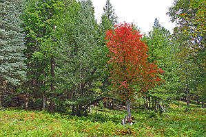
.. Prime Autumn "Big Tooth Maple" Bliss .. by Grasshopper  Warning Warning"Park / TH Start" is on the uppermost end of FR9731W at the intersection of FR139. FR9731W is not legal for any motorized vehicles. Overview This short, easy to navigate, off-trail Lasso Loop Hike within the Historic Cabin Loop Trails area of our Mogollon Rim should provide a most pleasant individual or family day hike into the very heart of multiple stands of Big Tooth Maples.. True Mogollon Rim "Autumn Bliss" during Prime Season.
Thanks to @kingsnake for first publishing Maverick Canyon - Merritt Draw Loop into this scenic and not topo map labeled Maverick Spur Canyon area. Finally, my first 8/20/21 (out-of-season) visit to view-confirm this awesome Big Tooth Maple area and now to issue this new HAZ Hike Guide so all Autumn Season lovers can enjoy. Hike From the recommended Park/TH Start (at coordinates 34.452526 -111.197224) and following my "Official Route", this short, totally off-trail, lasso loop hike immediately heads down into the uppermost end of an easy to navigate spur canyon (draw) drainage off Maverick Canyon and follows this widening drainage-draw down in elevation to intersect a decision waypoint at ~0.4 miles (protip: most all the large stands of Big Tooth Maples are within this first 0.4-mile). At ~0.4 miles in 34.457075 -111.196714, there are three options to continue this hike: 1) Turn around and head back to the Park/TH Start. 2) Turn NORTH and continue further down this now more widening, but still scenic Spur Canyon Drainage following the Official Route to the turn-around point. You could explore NORTH another 900ft to Maverick Canyon Draw proper at 34.464063 -111.18934. 3) Turn SE and follow the Official Route to intersect FR9731W back to Park/TH Start to complete this lasso loop hike. Water Sources If hiking to/within Maverick Canyon, perennial water sources should be present. Camping Multiple, remote with solitude Backpack Campsite options, available but possible perennial water sources only within Maverick Canyon. Synopsis I have yet to witness "Prime Autumn - Big Tooth Maple Season" for this section, but... of the local Cabin Loop area "Prime Big Tooth Maple Autumn" sections available, I speculate this to be in my top three! Check out the Official Route and Triplogs. Leave No Trace and +Add a Triplog after your hike to support this local community. | ||||||||||||||||||||||||||||||||||||||||||||||||||||||||||||||||||||||||||||||||||||||||||||||||||||||||||||||||||||||||||||||||||||||||||||||||||||||||||||||||||||||||||||||