Route Editor

| Guide | ♦ | 236 Triplogs | 2 Topics |
details | drive | permit | forecast | 🔥 route |
stats |
photos | triplogs | topics | location |
| 328 | 236 | 2 |
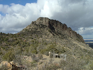
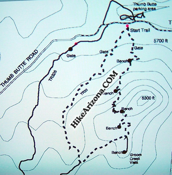
a family hike by ck_1  Anyone spending time in Prescott notices Thumb Butte. I first saw it from the patio of the Tecate Grill (2001, gone now). Thumb Butte rises above the area just west of town. My first thought was, "That's got to be a great hike". On our second trip to Prescott, we thought we would see for ourselves. To reach the trailhead, you drive through town on Gurley Street that turns into Thumb Butte Road. You'll enter the forest and notice the picnic and parking area to the right, trailhead to the left. Anyone spending time in Prescott notices Thumb Butte. I first saw it from the patio of the Tecate Grill (2001, gone now). Thumb Butte rises above the area just west of town. My first thought was, "That's got to be a great hike". On our second trip to Prescott, we thought we would see for ourselves. To reach the trailhead, you drive through town on Gurley Street that turns into Thumb Butte Road. You'll enter the forest and notice the picnic and parking area to the right, trailhead to the left.Any dreams of a challenging hike left almost immediately upon parking. After paying a nominal fee to park, we headed up the trail. The people around the area ranged in age from the very young to the very old. With Thumb Butte being the main attraction, my expectations for the hike quickly changed.
Once reaching the vista point, we encountered dozens of small children and families of all ages. The trail, having returned to dirt, weaves around the vista area. There is a spur trail heading to the true summit of the butte. We explored it a bit, but with the large crowd, we didn't want to encourage others to follow, as the spur trail was more strenuous and dangerous with loose rock. The view from the trail was spectacular, as the town of Prescott, Granite Mountain, Mingus Mountain, and the Bradshaw Mountains were all visible. Your elevation at the saddle is 6,200 feet. We headed back down on the main trail, which returned to blacktop and railings for the descent back to the trailhead. The slope of the trail is angled just enough to be annoying. I would caution hikers to avoid the trail if icy, as you may slide all the way to your car. Thumb Butte Trail #33 is an excellent hike for a family looking for an hour or so outside. It is genuinely disability accessible. Although I would recommend hiking counter-clockwise, someone using a wheelchair could take the trail clockwise. They would most likely require a stout aide to assist in the uphill. The trail would be excellent for trail runners, as the elevation gain would allow for a good workout. This trail is more park-like than a forest. The area is clean and well kept. There are plenty of picnic tables and ramadas available across the street. Or better yet, eat at the Tecate Grill!
Prescott FS Details
Check out the Official Route and Triplogs. Leave No Trace and +Add a Triplog after your hike to support this local community. | ||||||||||||||||||||||||||||||||||||||||||||||||||||||||||||||||||||||||||||||||||||||||||||||||||||||||||||||||||||||||||||||||||||||||||||||||||||||||||||||||||||||||||||||||||||||||||||||||||