Route Editor

| Guide | ♦ | 1 Triplog | 0 Topics |
details | drive | no permit | forecast | route |
stats |
photos | triplog | topics | location |
| 29 | 1 | 0 |
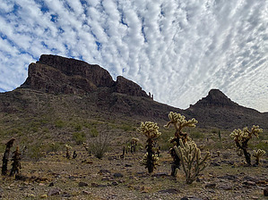
Follow the Game Trails by GrangerGuy  Overview OverviewHiking in washes and following game trails, this 12-13 mile circuit around Big Horn Peak makes a great and not difficult adventure, not too far from Phoenix. Prologue Not far from Phoenix is the little-visited Big Horn Mountains Wilderness. This area is just north of I-10, and just a little west of the hamlet of Tonopah. At the heart of it is Big Horn Peak, which has a guide, and an advanced ridge walk which also has a guide. Both of those routes are for scramble climbers, but those of less skill should not miss this place, for its loneliness and beauty. From high in the passes, the view is almost as good as from the ridgetops, and a lot less scary.
The clockwise loop is preferred, I think, as it puts you through the most difficult section early, while you are still fresh. From the parking spot, follow a short jeep road down to the wash, and turn right in the wash. Travel is easy in the wide sandy wash, although at times you have to pick the route that avoids the Acacia trees blocking the way. At around 0.6 mi, the wash goes through some narrow rocks, an easy, short climb up to the next level. There is a pool there which could be a possible water source. Nearby, I spotted a family of javelinas, who kept a wary distance and snorted at me a lot. At about 1 mi, at a fork in the wash, bear left. Note that when you return, you will come in on the other fork. Soon after, the wash passes through a rocky, narrow, and beautiful canyon; one of several you will walk today. Eventually, travel gets easier up on top of the plain, rather than down in the washes, and you can see the first pass as you come up out of the wash. At 1.8 miles, you have to cross a pretty deep wash, but it is not difficult to find a way. From there, it is a matter of following the animal trails up to the top of the first pass, at about 2 miles. The climb down from the pass to the south is probably the most challenging bit of walking, as it is a little steep with some loose rock. Take your time, follow the animal tracks where possible, and you should have no difficulty. Trekking poles make it much easier. In 0.3 miles from the pass, it levels out some and gets a lot easier. Stay in the wash for easy navigation. I continued down the wash almost to the edge of the wilderness. [I realized later that it would make as much sense to bear right about the time you cross the 1750’ contour, follow the base of the mountain, and aim for the small pass in the ridge to your right. This would cut off some distance and avoid a less fun walk across the bajada straight south. Once crossing the pass, stay in the bajada or the large wash close to Big Horn Mountain, until you pick up the route again.] My route followed the wash until I took a sharp right turn and went around the end of the ridge just described, at about 5 miles into the trip. Travel in this area is easy and fast. Follow a beeline to the northwest around the next two ridges, and then turn north at about 6.5 mi. Travel is easy if you set your compass on waypoints far ahead, and then go as directly as you can toward the waypoint. Beware of the cholla as you get to the north end of this trip segment. The plants are spaced plenty far apart, but they have scattered many burrs on the ground which match the color of the dirt. You have to spend time looking where you put your feet. At about 8.8 miles, enter the wash climbing up to the east. Sometimes sandy and wide, and sometimes choked with vegetation, it remains interesting. Around 9.6 miles, you start climbing up through a canyon. There are many pools here. The canyon is beautiful. The only real hazard is the acacia tree with its long thorns and some catclaw acacia. Avoiding them makes for slow going. I think if I walked this again, I would carry pruning shears. At about 10 miles, the canyon broadens. With about 250’ to climb over the last mile to the pass, travel is easier. You arrive at the last pass at about 10.9 miles. The climb down from this pass is easy. From here, it is just a matter of following the drainage back down to your car. It is a matter of taste, whether you walk in the washes or on top. At 11.6 miles, you rejoin your starting path, and then it is a quick mile back to your car. Water Sources In the canyon on the north side of the loop are many rocky pools that were filled at the time of this writing (January 2022) Check out the Official Route and Triplog. Leave No Trace and +Add a Triplog after your hike to support this local community. | ||||||||||||||||||||||||||||||||||||||||||||||||||||||||||||||||||||||||||||||||||||||||||||||||