Route Editor

| Guide | 0 Triplogs | 0 Topics |
details | drive | permit | forecast | route |
stats |
photos | triplogs | topics | location |
| 3 | 0 | 0 |
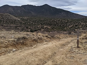
copper, silver mine by freewilley  The hike starts on the UX Road (FSR 4675) off of the Duquesne rd. Park at the first gate which has room for 4 vehicles. The hike starts on the UX Road (FSR 4675) off of the Duquesne rd. Park at the first gate which has room for 4 vehicles.Note: If you want to shorten the hike, the first half mile is drivable by high clearance vehicle and you could park in the first canyon, which is Providencia. In any case, go downhill when you meet the Providencia canyon. This is a very pleasant canyon with rock waterfalls. Proceed downhill until you meet the first road and turn right. Take this road uphill to the Jackalo mine where you will have fantastic views to the west. Note the beautiful stone dam at the junction of the road.
There are many other undocumented hikes in this area. For instance, you can follow the UX road uphill past the four metals mine all the way to Harshaw road. Or take the Providencia canyon further downhill and turn around when desired. Gate Policy: If a gate is closed upon arrival, leave it closed after you go through. If it is open, leave it open. Leaving a closed gate open may put cattle in danger. Closing an open gate may cut them off from water. Please be respectful, leave gates as found. The exception is signage on the gate directing you otherwise. Check out the Official Route. Leave No Trace and +Add a Triplog after your hike to support this local community. | |||||||||||||||||||||||||||||||||||||||||||||||||||||||||||||||||||||||||||||||||||||||||