Route Editor

| Guide | 0 Triplogs | 0 Topics |
details | drive | permit | forecast | 🔥 route |
stats |
photos | triplogs | topics | location |
| 3 | 0 | 0 |
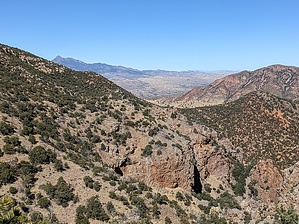
spy on the new mine! by freewilley   Overview OverviewClimb up an old FSR road to a saddle, down to a tributary, then over to Alum Gulch. The views are amazing including the San Rafael Valley to the east, and Mount Wrightson to the west. You look down on the new South 32 mine development (ugh) and then leave it behind when you descend into a pretty canyon and a 50-foot waterfall cliff. Hike Park at the intersection. FSR 4071 is a washed-out FSR road that climbs 700 feet over 1 ¼ mile through a pretty oak-covered dry creekbed (formerly a road). The road improves as you get higher.
Follow the road down into the valley. It drops 200 feet over ¾ mile into a drainage. Take the drainage downstream about 1/3 of a mile and look to your left. In a wash flowing into the drainage, you can make out a trail to the left. Follow that trail uphill and you will find the old road. Go right (I have not explored left yet, that road goes into another drainage to the west and ends at a mine..from the map) and follow the old road and enjoy the views into the drainage. It will end at an old mine so turn around when you like. If you go back to the drainage and proceed DOWN further in a very short while you will encounter a very steep rocky waterfall. When you turn around and meet the "road" you came down you can head further south on it and you will proceed through some great pines and hit the old Thunder Mine location, about 200 feet above the drainage. Water Sources No dependable water Camping At least 6 great free camping spots along Harshaw Road. Check out the Official Route. Leave No Trace and +Add a Triplog after your hike to support this local community. | |||||||||||||||||||||||||||||||||||||||||||||||||||||||||||||||||||||||||||||||||||||||||||||||