Route Editor

| Guide | 0 Triplogs | 0 Topics |
details | drive | permit | forecast | route |
stats |
photos | triplogs | topics | location |
| 3 | 0 | 0 |
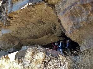
canyon with rocks and petroglyphs by freewilley  Warning WarningRoad down is serious 4x4 only. Once in the streambed, if the grass is long it is challenging to find the trail. Often I wait until cows have clipped it and go after New Years. Overview Ramanote canyon is beautiful and rarely hiked. There are 3 access points all but one requiring a 400 foot climb out (on old FSR roads). This TH is the one that can be driven to with a serious 4x4. This hike is one of 3 parts but of course, you can do the whole canyon if that works for you.
Old foundations in the bottom. Also, a petroglyph is talked about online but the location is not revealed. I believe it is in a cave on the east side, about the middle of this hike, about 15 feet above the streambed. Hike Park at the cattle gate at the bottom. Turn left (south) and walk along the fence without crossing through the gate. Soon you will be in the creek bed and will alternate between it and the frequent migrant trails you will see on either side. Enjoy the great views of the cliffs and sculpted rocks and caves as you follow the creekbed south. Several shaded lunch spots with rocky seats will become apparent in the area about 1 ½ to 2 miles from the start of the creek bed. Continue walking in the same southerly direction up the creekbed and you will come to a fence with a gate -- proceed through the gate. After a total of 3 hours and 20 minutes of hiking (including your ½ hour lunch break), you will come to a rock wall (the remains of an old corral??) just to the left of the creekbed, and off to your right-front will be a square-shaped mountain. It is easy to bushwack to Castle Tank which is close to the streambed. The GPS track ends at the other exit point... a faint trail up the hill which is shown on the Lion Mountain guide. Water Sources Often running, not always, but Castle Tank has water for your dog... Camping Sites on access road Note If you want to avoid the rough steep hill drive, park anywhere after the corral and just walk along the Mesa and down into the canyon. If you want to make this hike a loop, use the GPS Route on Lion Mountain. It documents the VERY faint trail supposedly on an old FSR road. And then hike up to the mesa and just follow it back to your vehicle. It is a pleasant walk as you are looking down into the canyon and the view is fabulous. I have done it both ways and they are both good. Ramanote Arch shows the same canyon south of here. You can access it by these directions or by the southern road past Toruno Tank. Gate Policy: If a gate is closed upon arrival, leave it closed after you go through. If it is open, leave it open. Leaving a closed gate open may put cattle in danger. Closing an open gate may cut them off from water. Please be respectful, leave gates as found. The exception is signage on the gate directing you otherwise. Check out the Official Route. Leave No Trace and +Add a Triplog after your hike to support this local community. | ||||||||||||||||||||||||||||||||||||||||||||||||||||||||||||||||||||||||||||||||||||||||||||