 Route Editor

| Guide | ♦ | 5 Triplogs | 0 Topics |
details | drive | permit | forecast | route |
stats |
photos | triplogs | topics | location |
| 9 | 5 | 0 |
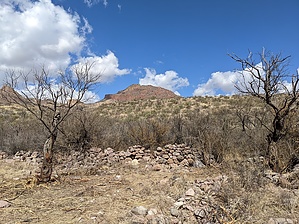
hidden GEM with ruins and views by freewilley  Warning WarningMojave Rattlesnakes are found in this canyon. They are more aggressive so careful in snake season. Overview This hike has an indigenous architectural site on the first peak to the south when you enter the canyon. This is a trinchera, which was a hilltop used for defense (maybe) and is one of several dozen in the southwest. Trincheras are entrenchments or fortifications in Spanish according to swvirtualmuseum.nau.edu
History Trinchera: ← summary and pics. Rock Corral: it was evident before, but recently someone cleared out the interior and it is much better to experience. Nobody knows who created this old structure. Mine: There is a white cross that supposedly marks the grave of a miner. Treasure: Many items online if you dig into it (pun intended). Prologue The hike can be 6 to 10 miles depending on the variation. The first decision is the starting point. If you do not have a serious 4x4 you need to park at I 19 frontage and walk. A 4x4 can take you 2 miles in where you will find the actual old corral and a great camp spot. One mile further and you will have walked through the wonderful canyon and rocky pools. There you will find a great stopping place on the cistern wall. The next leg ends up at an old mine site (with a grave marked with a cross) 1400 feet up and 2 miles in. The old road is quite rocky and steep. Hike Hike west and where the road forks, take the left fork onto FR 4145 and go down the hill. At approximately 1 hour into the hike, you will see the remains of a large rock corral on the left side of the road. At about 1 ½ hour into the hike, the road forks. The left fork goes about ½ mile and ends at a nice streambed; take the right fork and after about another 20 minutes, you will come to a rock cistern with a well, pump, and pump-house on the right side. This is a nice spot to have lunch in a little canyon with views of the distant mountains, lots of oak trees, and rock outcroppings. Or, if you want to go farther, there are plenty of other nice spots along the trail to stop for lunch. After another half-mile, the road rises quite steeply and has lots of potato-sized boulders up to the top. Then just hike back out the way you came in. Water Sources Even in dry times, you will find water in the pools. Camping Nice shady spot. Synopsis One of the prettiest canyons in the area. Walking in from the interstate means a mile or so of uninteresting terrain, but when you turn around and come down that road the views are pretty darn nice. You are staring at San Cayetano and the Santa Ritas and get a great view of the Santa Cruz Valley. Check out the Official Route and Triplogs. Leave No Trace and +Add a Triplog after your hike to support this local community. One-Way Notice This hike is listed as One-Way. When hiking several trails on a single "hike", log it with a generic name that describes the hike. Then link the trails traveled, check out the example. | ||||||||||||||||||||||||||||||||||||||||||||||||||||||||||||||||||||||||||||||||||||||


