Route Editor

| Guide | ♦ | 1 Triplog | 0 Topics |
details | drive | permit | forecast | route |
stats |
photos | triplog | topics | location |
| 15 | 1 | 0 |
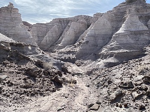
A step back 210 million years by GrangerGuy   Overview OverviewThis is roughly an 8-mile round trip lasso loop into the Petrified Forest Wilderness. The hike goes into the Black Forest Bed in the Petrified Forest Member of the Chinle Formation. You will be seeing petrified trees and rocks that are about 210 million years old. This mostly follows the Wilderness Loop handout available from the Visitor Center, one of several off-the-beaten-path hikes they suggest. Chances are, you will see no one out there. Hike The hike starts just to the left of Herbert Lore’s Painted Desert Inn, a little inside the park off I-40. There is plenty of parking. The trail drops sharply down several switchbacks, past junipers, Mormon tea, and some grasses. Once off the plateau, the trail passes through a pretty red canyon which is beautiful in the early morning light.
The route continues north and slightly west, to a jumble of rocks on a small ridge jutting out into the Lithodendron Wash. On that pile of rocks is the Flatiron Panel which contains a high density of petroglyphs. The glyphs include a range of animals, spirals, and rectangular patterns. The next section is confusing on the Park Service Handout. Cross the Lithodendron Wash to the northwest and proceed up the drainage into the steeper terrain. The pictures and map show a clear route up the drainage, but the coordinates of Gregory’s Stump do not match where it is plotted on their map. There is a stump with a section of root at the indicated coordinates, but even more interesting at that location is a standing stump 6-8’ high. The detour to the stump is not difficult. Perhaps there is another "Gregory’s Stump" that can be found as marked on the handout map. One continues north to Angel’s Garden, which includes several especially long, intact logs. As you proceed north, from Gregory’s Stump all the way to Chalcedony Forest, the handout says, “keep the red badlands to your right.” This is a little confusing because they are not particularly red, and there are other, redder, hills to the left. But there are badlands, and they really try to suck you in, and they are spectacular, but they are not the route. Pay attention to the route. Better to stay left, even left of the GPS route. Chalcedony Forest is another collection of petrified logs containing some unusual shapes, and colorful pieces poking up through the sand. Just a little beyond is the remains of a horse-drawn road grader, still with a couple of blades attached. There is no remaining evidence of roads out here, other than Lore’s Bridge and this grading implement. There is also no trail, so pay attention to your GPS or the pictures in the handout. Proceeding south from the Road Grader. Eventually, you will see an arm of badlands in front of you. You can go directly over this but going around it to the left is preferred. Make your way to the Lithdendron Forest, near Lithodendron Wash. This is perhaps the least interesting of the petrified forests you come across, but not bad. From there, follow a small sandy wash down to the main Lithodendron Wash, which you can follow directly west. You are close to the Onyx Bridge, which is not on the Park Service route, and it is worth a short half mile detour to see it. Where the Lithodendron Wash turns south, turn northwest up a small drainage, following it through dense scatterings of petrified chunks. As you get within about 100 yards of the bridge, keep left where the wash forks, and climb up to the bridge. After taking a few pictures, follow the drainage back down to Lithodendron Wash. You can cut off a big eastward bend of the wash and continue pretty much in a beeline across the grasslands south to the wilderness boundary, closing the loop on this route. Back on the well-worn path, you can continue following it south, back up onto the plateau, and finishing off at the Painted Desert Inn. Note The GPS route offered as the official route has a few sections edited from aerial photos and other sources, as the route I actually took in places was not optimal. The park is only open from 8 am to 5 pm.
Check out the Official Route and Triplog. Leave No Trace and +Add a Triplog after your hike to support this local community. | |||||||||||||||||||||||||||||||||||||||||||||||||||||||||||||||||||||||||||||||||||||