 Route Editor

| Guide | ♦ | 17 Triplogs | 1 Topic |
details | drive | permit | forecast | 🔥 route |
stats |
photos | triplogs | topic | location |
| 180 | 17 | 1 |
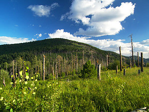
Do you want Flys with that? by PrestonSands  Overview OverviewFlys Peak, the second-highest summit in the Chiricahua Mountains at 9667 feet, is midway between Chiricahua Peak and the popular Rustler Park Trailhead. Flys Peak can be done as an easy out and back day hike from Rustler Park or included as a side hike along the Crest Trail. This description follows the Crest Trail #270 from Rustler Park to Flys Peak. One could also follow the Long Park Trail #42D from the end of the Rustler Park road for a shorter hike or an optional loop. Hike From the Rustler Park Trailhead, a short access trail climbs to the west from the parking lot and quickly arrives at a signed junction with the Crest Trail. Turn left onto the Crest Trail, which ascends gently, while heading south and east along a heavily wooded mountainside above Rustler Park. One can catch a brief view to the east of the San Simon Valley as the trail traverses below a cliff face.
Continuing south, the route finds itself in a thick covering of raspberry bushes as it crosses the steep western slope of peak 9308 and thereafter arrives atop a ridge overlooking Flys Park, where the round, forested dome of Flys Peak comes into view. The Crest Trail makes a gentle descent to the meadow at Flys Park, where it comes to a signed five-way trail junction. (31.87963 N, 109.28665 W) Turn onto the more primitive and somewhat overgrown Flys Peak Trail #337, which angles southeast, climbing a slope of post-fire aspens. Fallen, cut logs indicate the route, as the Flys Peak Trail zigzags up the northwest ridge of Flys Peak. Just over one-half mile above Flys Park, the Flys Peak Trail arrives at a cairned junction (31.873 N, 109.28483 W) among big trees, high on the western slope of Flys Peak. A spur trail to the summit doubles back to the north at the cairn, climbs a bit more, and quickly deposits you on the forested summit of Flys Peak, 3.5 miles from Rustler Park. A campsite exists, as well as a summit cairn and register. Heavy tree cover obscures most of the view. However, one can see Chiricahua Peak to the south and a bit of the surrounding area from a small open spot just below the summit cairn. Retrace your steps to return. Check out the Official Route and Triplogs. Leave No Trace and +Add a Triplog after your hike to support this local community. | ||||||||||||||||||||||||||||||||||||||||||||||||||||||||||||||||||||||||||||||||||||||||||||||||||||||||||||||||||||||||||||||||||||||||||||||||||||||||||||||||||||||||||||||||||||||||||||||||||||||||||||


