 Route Editor

| Guide | ♦ | 7 Triplogs | 1 Topic |
details | drive | permit | forecast | route |
stats |
photos | triplogs | topic | location |
| 112 | 7 | 1 |
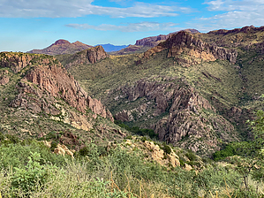
Shh, don’t tell anyone about this place by GrangerGuy   Overview After a long drive on a 4x4 road, hike about 600’ down into the canyon and spend hours exploring the canyons in 3 directions under a riparian canopy. Walking is easy with very little bushwhacking. There is water in the canyon, but not enough to get your feet wet. It might remind you of Aravaipa. The driving route described does not require crossing private land, but an Arizona Land Trust annual permit is required. Overview After a long drive on a 4x4 road, hike about 600’ down into the canyon and spend hours exploring the canyons in 3 directions under a riparian canopy. Walking is easy with very little bushwhacking. There is water in the canyon, but not enough to get your feet wet. It might remind you of Aravaipa. The driving route described does not require crossing private land, but an Arizona Land Trust annual permit is required.Background Redfield Canyon was added to the Wilderness System out of BLM land in 1990. It is unusual in that it is divided into two parts by the road from Muleshoe Ranch to Jackson Cabin. In most of Arizona, this would have generated two separate wilderness areas. Finding the actual boundaries of the wilderness is tricky. Different otherwise reliable maps give different answers. The Garmin Public Lands mapset at least is accurate as to what is not BLM and is private or State Trust land. The popular thing to do in this area has been to visit one of 3 abandoned cabins. Remember, though, all but Jackson Cabin are on private property. Instead of human ruins, enjoy the natural wilderness.
After dropping 600 sunny feet, you are suddenly in the cool shade of trees at the canyon bottom. If you were to go downstream (left), in about 600 yards, you would cross out of the wilderness into private property, and then maybe another 600 yards to an abandoned cabin. Another 500 yards beyond that, you would re-enter the wilderness and could explore further downstream. Instead, this guide recommends you go upstream (right) with easy walking. Sometimes the best route is on the left of the creek, sometimes the right, sometimes in a dry streambed, and sometimes getting the soles of your feet a little wet walking in the stream. The way is almost always obvious, and you can almost always walk around brushy obstacles. The official route I am including only goes up as far as the confluence with Swamp Springs Canyon, with a brief exploration up right and left at that junction. In principle, you could follow the Swamp Springs Canyon all the way to Jackson Cabin. This would make a cool one-way traverse of the wilderness, but the car shuttle would take you longer than the hike. You don’t have to walk far to truly enjoy this wild, beautiful, and rarely-visited wilderness.
Check out the Official Route and Triplogs. Leave No Trace and +Add a Triplog after your hike to support this local community. One-Way Notice This hike is listed as One-Way. When hiking several trails on a single "hike", log it with a generic name that describes the hike. Then link the trails traveled, check out the example. | ||||||||||||||||||||||||||||||||||||||||||||||||||||||||||||||||||||||||||||||||||||||||||||||||


