Route Editor

| Guide | ♦ | 1 Triplog | 0 Topics |
details | drive | permit | forecast | route |
stats |
photos | triplog | topics | location |
| 14 | 1 | 0 |
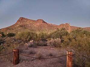
Not the cartoon by Mike_W  Overview OverviewPink Panther Peak is a challenging steep rock climb near the top 0.25 miles, but the rest of the hike involves good trails/road in and around Panther Wash and almost all the way to the saddle North of Pink Panther peak. 90% of the hike is fairly easy and can be enjoyable for almost anyone. Going to Panther Peak is definitely not for everyone. Hike From the corner on West Ina road in the town of Picture Rocks, start heading on the trail leading north. After 200 feet, you should see a good trail heading east toward Panther Wash. Take this trail in the direction of Panther Wash which you will want to cross. When you get close to the wash you may need to do a small amount of bushwhacking to get into the wash. By the time you reach the wash, you would have traveled roughly 0.35 miles. Cross the wash and look for packrat/deer trails leading in the direction of the saddle North of Pink Panther Peak. The terrain is open desert and the walking is quite easy here, even when you're off-trail. Continue working your way toward the saddle. When you get close to the saddle the brush can get a bit thicker. Stay away from the teddy bear chollas and you should be fine.
If you choose to climb, be sure you are comfortable with climbing. There are steep grades here, even some cliffs, and the potential for injury or death if you don't know what you're doing. The climb up got progressively steeper and steeper until I appeared to be within 30-50 feet from the very top. There was a very steep rock section which I was able to climb because of irregularities in the rock. This climb put my limits to the test and luckily I had a good headlamp. While climbing up, I thought I wouldn't want to go down this way, especially at night. I made it to the top and by this time it was already dark. On the way down I chose a better route, and you may be better off going up this way if you're not comfortable climbing the steep rocky section that I climbed. From the peak, heading down, I ended up scrambling about 100 feet to the East down a rocky chute and then scrambled another 200 feet north down another rocky chute. As I got closer to the saddle, the trail leveled out more and the hiking got much easier. Watch out for the teddy bear chollas near the saddle. From the saddle, hike west and north down the hill and eventually you'll run into an old road. This road/trail leads west toward Panther Wash, crosses it after about 0.3 miles, and then eventually joins another trail that runs north/south. Take that trail south about 0.3 more miles to get back to the main trailhead.
Check out the Official Route and Triplog. Note This is a moderately difficult hike. Leave No Trace and +Add a Triplog after your hike to support this local community. | |||||||||||||||||||||||||||||||||||||||||||||||||||||||||||||||||||||||||||||||||||||||||||||||||||