Route Editor

| Guide | ♦ | 1 Triplog | 0 Topics |
details | drive | no permit | forecast | route |
stats |
photos | triplog | topics | location |
| 34 | 1 | 0 |
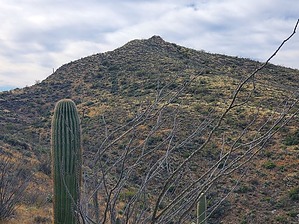
Can I have some salsa with that? by Mike_W  Overview OverviewThe Tortilla Benchmark, not to be confused with the Tortolitas Benchmark, is one of the high points on the northern side of the Tortolita Mountains. There is no official trail, but there are many good cattle trails, making it an easy bushwhack, most of the way. This high point is quite far from the more popular Wild Burro trailhead, and is accessed from a different side of the range. You'll need a 4x4 vehicle and high clearance for much of the dirt road. From Missile Base Road, it's roughly 7 miles of paved road and just over 10 miles of dirt / 4x4 road.
From the parking area mentioned below, you will be hiking south to get to the peak. Within the first few minutes of hiking, you should see a cattle tank and corral area. When I passed by this area, I saw a few cattle hanging out in the shade. Continue south and use the cattle trails to get higher in elevation. When I reached the first saddle, there were some cattle. They seemed surprised to see me. One turned quickly and looked right at me and then waited about 10 seconds. Then, the group of cattle started descending the back side. I continued following cattle trails and made it to a second high point. From there, I could see the ridge and the peak to the right of the ridge. I followed the ridge, noticing that cattle often roamed this area. Then, I hiked the last 200 feet of elevation to get to the top. The bushwhack at the very end was thicker than the rest, I suppose because the cows probably don't go to the very top of this peak. The top of the peak is quite rocky and not ideal for cows. At the peak, you will see a registry covered with a pile of rocks, which is closer to the southern end of the high point. You can return the same way you came or you can descend the ridge on the back side, turn left, hike east, head toward the wash, cross it, and continue to summit the nearby Falcon Benchmark. Check out the Official Route and Triplog. Leave No Trace and +Add a Triplog after your hike to support this local community. | |||||||||||||||||||||||||||||||||||||||||||||||||||||||||||||||||||||||||||||||||||||