 Route Editor

| Guide | ♦ | 101 Triplogs | 0 Topics |
details | drive | no permit | forecast | route |
stats |
photos | triplogs | topics | location |
| 262 | 101 | 0 |
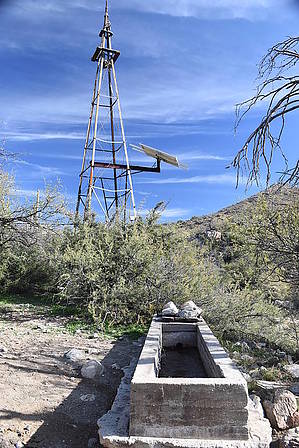
to the goat corral by markthurman53  Overview OverviewThe Wild Burro Trail is the backbone trail in the Tortolitas, this is the trail that connects you to all the others. The trail starts at the Ritz Carlton Hotel Trailhead parking lot. I did not see them but there are Petroglyphs just a couple hundred yards past the junction with the Lower Javelina Trail on the left. The trail is in good condition and all the junctions are signed and color-coded. Two line shacks can be seen along this trail. Which is a cabin for cowhands out patrolling the boundary line of the ranch for cattle that may have strayed over the line.
From the trailhead parking lot, head east down into the wash and color-coded signs direct you along the trail. The trail stays to either side of the wash and occasionally in the wash. Some have found it easier to just walk up the wash rather than the trail, either way. The first two miles is a gradual uphill climb as you follow the wash up the canyon. Pass the signed intersection with the Alamo Spring Trail, Upper Javelina Trail, Lower Javelina Trail, and at two miles the Alamo Spring Spur Trail. Fairly easy walking along this section although it could be interesting during the monsoons. At two miles in where the Alamo Spring Spur Trail breaks right the Wild Burro Trail heads out of the wash and begins some serious climbing along the west side of the creek to avoid a necking down of the canyon. Before heading up the side of the Canyon, check out the line shack. Can’t miss it, it is right on the trail. Some of the rock walls are still standing but the roof is gone. The trail climbs 300 feet in 0.3 miles and is definitely a change from the first 2 miles. Once over the rocks that caused the narrowing of the canyon the trail levels out as it follows Wild Burro Creek toward Alamo Spring. Before heading to Alamo Spring take the short Spur Trail that is marked to the overlook. Great views downstream. Along this spur trail, there is also some very interesting Gneiss rock that has been polished by the water. It is a good example of a glide fault that is quite common in Metamorphic Core Complexes. I found the geology along this spur trail more interesting than the view. Continue along the creek for a quarter-mile before exiting right to climb 200 feet up the east side of the canyon before dropping down into Alamo Spring. At Alamo Spring there is an informational sign about the location and believe it or not a metal “park bench”. Take advantage of it and take a break. Or you can do as I did and sit on the rock just to the south of the creek where the Hohokam Indians use to grind their seeds or grain. While sitting there you can’t help but contemplate that 900 years ago people sat at the same spot enjoying the views and the sun, except they were probably working while I’m sitting contemplating nothing important. I wonder what conversations they had here. While sitting on the rock the remains of an old dam that has long since filled with sand and a rock cement well can be seen immediately in front of you. Before leaving Alamo Spring take a short 100-yard walk up to the second of the two line shacks along this trail. This side trip is also marked by a sign. This shack is in worse condition than the one seen earlier, only the lower rock walls can be seen and portions of the metal and wood roof scattered about. The Wild Burro Trail from here to the Water Tank and windmill was completed in 2010. The 2.9-mile section of trail climbs gradually to the Windmill and Goat Corral. The signed Wild Mustang Trail exits left about 0.4 miles from Alamo Spring. The trail continues up Wild Burro Canyon, now more of a basin than a canyon along the west side a short distance uphill from the creek. This portion of the trail from Alamo Spring is very exposed with little shade. At the end of the Wild Burro Trail, the windmill has gone high-tech with solar instead of wind power. The water tank was filled to the brim and the wasps were happy. A couple hundred yards to the east of the windmill is the rock corral used to contain sheep or cattle. Quite an impressive rock structure. Check out the Official Route and Triplogs. Leave No Trace and +Add a Triplog after your hike to support this local community. One-Way Notice This hike is listed as One-Way. When hiking several trails on a single "hike", log it with a generic name that describes the hike. Then link the trails traveled, check out the example. | |||||||||||||||||||||||||||||||||||||||||||||||||||||||||||||||||||||||||||||||||||||||||||||||||||||||||||||||||||||||||||||||||||||||||||||||||||||||||||||||||||||||||||||||||||||||||||||||


