Route Editor

| Guide | ♦ | 17 Triplogs | 0 Topics |
details | drive | permit | forecast | 🔥 route |
stats |
photos | triplogs | topics | location |
| 231 | 17 | 0 |
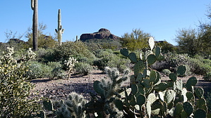
 Warning WarningThe park has no electricity, water, or trash service, so campers must pack in what they need and pack out all waste. (No RV camping, tent-only) Overview [ 2023 Map ] Peralta Regional Park is situated adjacent to Peralta Road just south of the Superstition Mountains. It includes the following amenities: * Equestrian Staging Area * 9+ miles of multi-use NON-motorized trails with varying difficulty * 18 Picnic Sites and 2 Large Group Picnic Sites * Stargazing Node for setting up a telescope * 31 Remote Campsites * Interpretive trail with educational panels * Waterless Restrooms The park is open from dawn to 10:00 pm for day-use guests. Check local sunrise times when planning your visit.
A master plan was created in 2015 and the park opened to the public on January 12, 2023. TRAILS Interpretive Trail = 0.528 miles Difficulty Beginner Features: * Six educational interpretive panels 1. Bats are the heroes of the night! 2. The Living History of the landscape 3. Quarter Circle U Ranch 4. The Sonoran Desert Tortoise thrives in desert environments 5. Superstition's Mineral Legacy 6. Bighorn Sheep are amazingly agile * Sitting benches * Harder surface trail, good for strollers, wheelchairs, etc. * NO EQUESTRIANS! Serenity Loop = 1.263 miles Difficulty Beginner/Intermediate Features: * Intersects with Interpretive Trail * Many picnic ramadas are nearby Desperado Trail = 2.659 miles Difficulty Intermediate/Advanced Features: * Longest trail option * Connects to most other trail loops * Begins at the horse staging parking lot on the West end of the park * Desert riparian area experience on portions of the trail * East portion of the trail requires some route-finding skills * A full half-mile along the East portion provides complete solitude (No buildings/vehicles visible) * North Star Trail is a spur trail from near the middle of Desperado Trail North Star Trail = 0.278 miles Difficulty Advanced/Expert Features: * The end of the trail is the highest trail point in the park * Great views * The trail DOES NOT reach the summit of the peak, which is outside the park boundary * Two crested arm saguaros visible from the end of the trail point * The upper portion of the trail is not recommended for bicycles * No equestrians on the upper portions of the trail. This area has "No Equestrian" signage Saguaro Loop = 1.214 miles Difficulty Intermediate Features: * Hole-in-the-Rock Arch * Scenic views of the Superstition Mountains * Begins/ends at the NE end of the Desperado Trail ORO VISTA LOOP = 1.093 miles Difficulty Intermediate/Advanced Features: * Very narrow single track on the northwest portion of the loop * View/rest spot at the very north end of the trail * Scenic views of the Superstition Mountains Wanderer Trail = 0.433 miles Difficulty Intermediate/Advanced (to get to the trail), beginner once on the trail Features: * Ridgeline trail with great 360-degree views on most of the trail * Scenic views of the Superstition Mountains * Intersects with the view/rest spot on the Oro Vista Loop Stargazing Trail = 0.278 miles Difficulty Beginner/Intermediate Features: * Stargazing Node * Several wash crossings
Check out the Official Route and Triplogs. Leave No Trace and +Add a Triplog after your hike to support this local community. | ||||||||||||||||||||||||||||||||||||||||||||||||||||||||||||||||||||||||||||||||||||||||||||||||||||