Route Editor

| Guide | ♦ | 2 Triplogs | 0 Topics |
details | drive | permit | forecast | route |
stats |
photos | triplogs | topics | location |
| 46 | 2 | 0 |
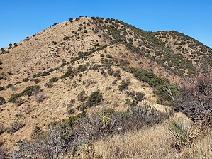
Chips and Sala by DixieFlyer  Overview OverviewThe Sala Benchmark (elevation of 7,144 feet and prominence of 1,264 feet) is near Tombstone, AZ in the Dragoon Mountains. This unnamed peak is marked as "7144" on topographic maps. Hike From the parking area, ascend west up a slope to a ridgeline at the top of the slope. There is a fence at the cattle guard where you park; you'll want to be on the left side of the fence as you ascend. The slope is somewhat steep, but it is short (you'll gain about 200 feet of elevation in 0.15 miles). There is a bit of vegetation on the slope, but anything sharp or pointy is easy to walk around.
The use trail generally stays to the left of the top of the ridgeline, thus reducing some of the ups-and-downs along the ridgeline. At the summit, there are nice 360-degree views of the southeastern Arizona sky island ranges. The benchmark and both reference marks are stamped "Sala". There is also a metal height-of-light pole at the summit that is standing. Return the way that you came. Synopsis This short hike is scenic and will give you a good workout. Check out the Official Route and Triplogs. Leave No Trace and +Add a Triplog after your hike to support this local community. | ||||||||||||||||||||||||||||||||||||||||||||||||||||||||||||||||||||||||||||||||||||||||||||