Route Editor

| Guide | ♦ | 1 Triplog | 0 Topics |
details | drive | no permit | forecast | 🔥 route |
stats |
photos | triplog | topics | location |
| 9 | 1 | 0 |
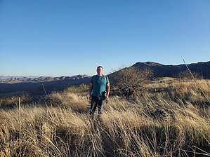
Future site of the Rincon Foothills luxury homes! by Mike_W  Overview OverviewWhite Ridge high point is an interesting area east of Espiritu (Spirit) Canyon and part of the Rincon Mountain Wilderness area. A small part of this hike is on a road, but the majority of this hike is a bushwhack with a fair amount of catclaw bush and shin dagger. The good news is you can go around most of it and maybe all of it if you choose your route very carefully. If you attempt this hike, definitely wear long pants and a long sleeve shirt. You may want to even bring a cutting tool for those stubborn catclaw vines that are in your way! Hike If you parked where I parked, walk east down the 4x4 road for 1/3 of a mile until you reach Espiritu canyon. From here, you will continue on the road going south through the canyon for another 1/3 mile. Somewhere in this area, the road splits and there will be a section going out of the canyon in both directions.
At this point, White Ridge will be to the southeast. You will not be able to see the top, but you will want to climb to the highest point that you can see. There are some animal trails in this area that will eventually lead you to the top of the ridgeline. Once on the ridgeline continue south/southeast and stay on top of the ridge. You will see a barbed wire fence to your left which you may want to eventually cross to stay on the top of the ridge. Along the way, there are some ups and downs and you may see some giant barrel cacti, giant saguaros, and some pincushion cacti. Avoid the catclaw bush, shin dagger, and prickly pear, and you should be fine. Continue heading up the ridge until you reach the high point which is at 4745 feet elevation. There's a rock pile with a registry near the high point. This point only seems to get a few visitors every 5 years!
Check out the Official Route and Triplog. Leave No Trace and +Add a Triplog after your hike to support this local community. | ||||||||||||||||||||||||||||||||||||||||||||||||||||||||||||||||||||||||||||||||||||||||||||||