username
X
password
register
for free!
help
   🔥

Imperial Refuge Wilderness Traverse, AZ

Guide 1 Triplog  0 Topics
  3 of 5 
Fav
Wish
0
details
drive
permit
forecast
🔥
route  
stats
photos
triplog
topics
location
10 1 0
Statistics
tap icons for details
Difficulty 1.5 of 5
Route Finding 2 of 5
Distance Round Trip 5.5 miles
Trailhead Elevation 202 feet
Elevation Gain 385 feet
Accumulated Gain 725 feet
Avg Time Round Trip 4 hours
Kokopelli Seeds 9.13
 Interest Off-Trail Hiking
 Backpack No
 Dogs not allowed
feature photo
Photos Viewed All MineFollowing
Will recalculate on button tap!
10  2023-03-16 GrangerGuy
Author
author avatar Guides 26
Routes 101
Photos 688
Trips 78 map ( 891 miles )
Age 66 Male Gender
Location Phoenix, AZ
Historical Weather
Trailhead Forecast
Radar Map
Expand Map
Preferred Dec, Jan, Feb, Mar → 7 AM
Seasons   Late Autumn to Early Spring
Sun  5:31am - 7:42pm
Official Route
 
0 Alternative
 
 Water
Historic Fire Perimeteracres
🔥 2013 ISLAND LAKE Fire26.2 mi*


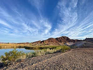
Imperial Walkers Ahead
by GrangerGuy

Overview
Take a short boat ride on the Colorado River and pull up through a cut in the jungle on the Arizona side of the river. Walk across the Refuge Wilderness, enjoying solitude, and talking to the burros who may hiss back at you. The Imperial Refuge Wilderness is there to protect desert tortoises, who come out around late March, and bighorn sheep. It also is home to a number of burros, that have made a network of trails.


Hike
Access is by kayak or motorboat. Locate the cut in the tall weeds a little south of Nortons Landing. The cut is only 6 or 8 feet wide, so the GPS track of the official route, or review of aerial photos, is mandatory. Tie up or pull your boat on shore and start following the burro tracks.

As you head up the hill, the trail traverses left along the side of a hogback. At first, it looks like the trail is going off the edge, but the burros know what they are doing as they cut around the hogback. Once past that section, the trail is very easy. The colors and landforms almost look like the wreckage of mining, but I don’t think so. I think it is just “painted desert.”


The route continues northeast, climbing gently, finally arriving at a ridge at the northern boundary of the wilderness. Nothing in this area seems to have an official name. Basically, this trip just is an exploration of the refuge wilderness. Likely you see or hear burros. Possibly you will see desert tortoises, bighorn sheep, or evidence of them. There are beavertail cacti, with their pretty pink flowers in the springtime.

Check out the Official Route and Triplog.

Leave No Trace and +Add a Triplog after your hike to support this local community.

2023-03-24 GrangerGuy
    WARNING! Hiking and outdoor related sports can be dangerous. Be responsible and prepare for the trip. Study the area you are entering and plan accordingly. Dress for the current and unexpected weather changes. Take plenty of water. Never go alone. Make an itinerary with your plan(s), route(s), destination(s) and expected return time. Give your itinerary to trusted family and/or friends.

     Permit $$
    Special Use

    Special
    This Arizona hike begins in California. See this CA State Park hike for the current link to details and lookup Pichaco.


     Directions
    or
    or
     Road
    FR / Jeep Road - Car possible when dry

    To hike
    Access is by boat from Picacho State Recreation Area on the California side. Camping is $20 per night, or day use is $10 per day. Motor boat launching is $5, but kayak launching is free. Payment is by cash or check. From Yuma, take Picacho Road about 22 miles north to Picacho SRA, and drive to the Taylor Lake boat launch. A high clearance vehicle is suggested. Car possible when dry. Navigate out of Taylor Lake, and slightly upstream to land in a cut in the weeds on the Arizona side.
    page created by GrangerGuy on Mar 24 2023 3:59 pm
     90+° 8am - 6pm kills
    helpcorrectionissue

    end of page marker