Route Editor

| Guide | ♦ | 2 Triplogs | 0 Topics |
details | drive | no permit | forecast | route |
stats |
photos | triplogs | topics | location |
| 72 | 2 | 0 |
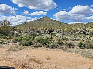
the "other" Coyote peak by Mike_W  Overview OverviewCoyote peak in Pinal County is not to be confused with the much larger Coyote Peak in the Coyote Mountains. From the parking area, it is an open country hike to a ridgeline, then a hike up the ridgeline following a barbed wire fence to a rocky peak. To the East is private property and a ranch called Coyote Ranch. Although there is no formal trail, cows have grazed much of the area, so the brush isn't bad at all. Hike From my parking spot, here, I walked north and within roughly a hundred feet, I saw a road that was apparently used for a high-pressure gas line. There were a few signs indicating this. I followed the road northeast for about 1/2 mile that I realized this road was going too far to the east. From here, I decided to start my "open country" hike and head north. After heading north for about 200 feet, I saw a barbed wire fence. I didn't see any way around this, so I went under the fence and kept hiking north toward Coyote peak. The hike through the open country terrain was pleasant. There were a lot of teddy bear chollas, but I didn't have to get close to any of them, as there was a lot of open space. There was also a lot of dry grass that had been trampled over, probably by cattle. It was easy to find a clear path through. I suppose we can thank the cattle for grazing and clearing this area.
I made it to the peak which contained a lot of rock and also found a glass jar registry with entries going back as far as 1995. Near the top, there were some birds nesting and I didn't get a close look, but they were probably turkey vultures. I also saw evidence of cattle making it nearly all the way to the peak but didn't see any cattle anywhere on this hike. It is incredible how these cattle can climb these steeper grades. On the way down, I decided to follow the barbed wire fence all the way and it ended at a corral on private property. Then, the fence turned west and paralleled the road. I followed this fence 600 feet past where I parked to see if there was an opening or end to it and I wasn't so lucky. Anyway, I ducked under the fence and walked back over to where I parked to complete my hike. Check out the Official Route and Triplogs. Leave No Trace and +Add a Triplog after your hike to support this local community. | ||||||||||||||||||||||||||||||||||||||||||||||||||||||||||||||||||||||||||||||||||||||||