 Route Editor

| Guide | ♦ | 1 Triplog | 0 Topics |
details | drive | permit | forecast | route |
stats |
photos | triplog | topics | location |
| 16 | 1 | 0 |
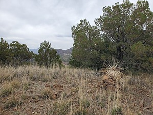
beautiful by Mike_W   Overview OverviewHermosa Hill, which means beautiful hill in English, is roughly a 500-foot hill near Harshaw, AZ in the Patagonia mountains. There's some private property in this area, but there are a few possible routes that involve an open country hike with light brush. Hike Knowing that it was not possible to walk the restricted road going up, I followed an open gully to the north that basically paralleled the main road for about 1/2 mile. Then, I decided to hike east, climbing up higher. After a few minutes, I saw a yellow cord/wire, which could have been for phone/internet and I followed it up higher for a while. The yellow cord kept going higher but did not go to the summit. Instead, it headed toward the north side of Hermosa Hill. I didn't see any fences here or any private property signs. Eventually, I was able to make the summit.
Check out the Official Route and Triplog. Leave No Trace and +Add a Triplog after your hike to support this local community. One-Way Notice This hike is listed as One-Way. When hiking several trails on a single "hike", log it with a generic name that describes the hike. Then link the trails traveled, check out the example. | |||||||||||||||||||||||||||||||||||||||||||||||||||||||||||||||||||||||||||||||||||||


