Route Editor

| Guide | ♦ | 1 Triplog | 0 Topics |
details | drive | permit | forecast | route |
stats |
photos | triplog | topics | location |
| 10 | 1 | 0 |
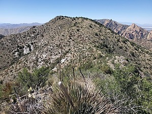
only 10 feet lower than China peak by Mike_W   Overview OverviewPeak 7115 is about 1.25 miles North of China peak, as the crow flies. Much of the hike follows a fence line across a ridge but there's a way to avoid some of the brush by taking a road called FS 345 A for part of the hike. Hike There are 2 decent ways to summit this peak. The shortest and most direct way is to follow FS 697 North to China Peak. It is possible to drive up much of this road, especially the lower section, but it gets quite steep near the top. After about 2 miles up FS 697 you will pass through a natural gateway in the rock and at the 2.2-mile mark, you will see some campsites on the left side of the road. You can walk or drive this part of the road but I found it enjoyable to walk the road.
From this point, I found it easiest to follow the fence line along the ridge. The trail was pretty easy to follow although there were probably 2 or 3 rrushy areas along the way. I was able to get around each of these areas. Again, there are times when you will want to cross the fence because the terrain looks easier on the other side. You will need to travel a total of 0.9 miles from the pass along the ridgeline to get to the peak. When getting close to the peak, you will need to curve to the West to get to the high point. At this high point, I found a registry with names going back to 2011. To get back down you can follow the same route you took to get here or once you are on FS 345 A, you can take that all the way down and back to the parking area near FS 697. I decided to take FS 345 A all the way back because it was uncharted territory for me. Even though it's longer in terms of distance, you won't need to re-climb China Peak to get back to the road. Gate Policy: If a gate is closed upon arrival, leave it closed after you go through. If it is open, leave it open. Leaving a closed gate open may put cattle in danger. Closing an open gate may cut them off from water. Please be respectful, leave gates as found. The exception is signage on the gate directing you otherwise. Check out the Official Route and Triplog. Leave No Trace and +Add a Triplog after your hike to support this local community. | |||||||||||||||||||||||||||||||||||||||||||||||||||||||||||||||||||||||||||||||||||||||||||||||