Route Editor

| Guide | ♦ | 1 Triplog | 0 Topics |
details | drive | permit | forecast | route |
stats |
photos | triplog | topics | location |
| 28 | 1 | 0 |
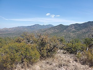
Tiffany nor the Shondells spotted alone by Mike_W   Overview OverviewLone Mountain, in the Huachucas, is a massive ridgeline that extends for over 2 miles. The high point, which is on the northwest end, has an elevation of 6,479 feet. There are no trails that I'm aware of, except for some animal trails and migrant trails, but there are 2 or 3 published/known routes to get to the summit depending on if you're coming from the west or east. This guide describes how to reach the summit starting from the west. Hike Follow the unmarked FS 4755 north from the campground site. At the very beginning, you will cross through a primitive gate. You will cross a canyon in the first 0.2 miles and then head up to a ridge after that. After hiking a total of 1.22 miles, you should see a split in the road with a sign labeled 4755-A. Turn right here and continue for 0.22 miles. You should be at a low point. Turn left here and walk down into the wash below which is Joaquin Creek.
There was one section near the end that had about a 20-foot drop, but I was able to take my time and find a groove in the rock where I could safely descend. I made it to the top and found a rock pile with a registry. Return the way you came, or if you feel adventurous, you could try taking the southern part of my route which wasn't quite as scenic as the northern route. Gate Policy: If a gate is closed upon arrival, leave it closed after you go through. If it is open, leave it open. Leaving a closed gate open may put cattle in danger. Closing an open gate may cut them off from water. Please be respectful, leave gates as found. The exception is signage on the gate directing you otherwise. Check out the Official Route and Triplog. Leave No Trace and +Add a Triplog after your hike to support this local community. | |||||||||||||||||||||||||||||||||||||||||||||||||||||||||||||||||||||||||||||||||||||||||||||||||||