username
X
password
register
for free!
help
 This is likely a great time to hike this trail!  Check out "Preferred" months below, keep in mind this is an estimate. 
   🔥

Spencer Peak 8206 - Catalinas, AZ

Guide 1 Triplog  0 Topics
  4 of 5  
Fav
Wish
0
details
drive
permit
forecast
🔥
route  
stats
photos
triplog
topics
location
17 1 0
Statistics
tap row or icons for details
Difficulty 3.5 of 5
Route Finding 2 of 5
Distance Round Trip 1.66 miles
Trailhead Elevation 7,734 feet
Elevation Gain 487 feet
Accumulated Gain 605 feet
Avg Time Round Trip 1.5 hours
Kokopelli Seeds 4.69
 Interest Off-Trail Hiking, Seasonal Creek, Perennial Creek & Peak
 Backpack Possible - Not Popular
unreported if dogs are allowed
editedit > ops > dogs to adjust
feature photo
Photos Viewed All MineFollowing
Inaugural Calculation on Button Tap!
17  2023-07-08 Mike_W
Author
author avatar Guides 104
Routes 256
Photos 16,118
Trips 528 map ( 2,863 miles )
Age 53 Male Gender
Location Tucson, AZ
Historical Weather
Trailhead Forecast
Radar Map
Expand Map
Preferred Apr, May, Sep, Oct → 9 AM
Seasons   Spring to Autumn
Sun  6:00am - 6:44pm
Official Route
 
0 Alternative
 
Historic Fire Perimetersacres
🔥 2020 Bighorn Fire119.5k
🔥 2003 Aspen Fire87.7 mi*
🔥 2002 Bullock46.8 mi*
🔥 View (All) - over Official Route 🔥
*perimeter length in miles


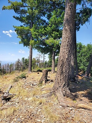
A great shaded hike to escape the heat in summer!
by Mike_W

 Likely In-Season! 
Overview
Spencer Peak, at 8,206 feet elevation is a short and steep hike but there is no official trail. Probably the easiest way to summit is from Spencer Campground. But, if you want a more challenging option, the hike from the trailhead for Sunset Trail #90 to Spencer Peak is a great option. It also has a lot of shade and was comfortable for me, even on the hottest days of the summer in July.


Hike
From the Sunset Trailhead, hike south and you will see a trail that curves around and goes downhill. You will cross a bridge going over a stream, then turn left. Within a short distance, you will see a steep trail leading up to the right side. This trail seems to disappear after about 20 feet but you are headed in the correct direction (up). At times you may see green square markers or pink ribbons on trees, which are good to follow as long as they go up. You may also see some faint animal trails leading up which I found useful. Almost my entire route from the bottom to the peak was shaded.
remove free decal offer
After hiking about 0.6 miles, you might reach a high point that is surrounded by Gambel oak and not see anything higher in all directions. You might feel like you are at the peak, but you are not quite there. The peak is about 500 feet to the south and only about 25 feet higher than where you are. You'll need to drop down a bit a go around some brush including a dense field of ferns.

When you are at the peak, you will see a few pines and a fire ring made of rocks. You won't have any good views of the city, but you will see a lot of nature around you, mostly pines and rolling hills. To get down, you can follow the same route, but I found it to be slightly faster and more enjoyable to follow the pink ribbons. You may need to search a bit from one ribbon to the next, but that's part of the fun. The pink ribbons will lead you down to a trail that follows the road. From this trail, turn left to get back to the Sunset trailhead.

2023-07-09 Mike_W


    Check out the Official Route and Triplog.
    Leave No Trace and +Add a Triplog after your hike to support this local community.
    WARNING! Hiking and outdoor related sports can be dangerous. Be responsible and prepare for the trip. Study the area you are entering and plan accordingly. Dress for the current and unexpected weather changes. Take plenty of water. Never go alone. Make an itinerary with your plan(s), route(s), destination(s) and expected return time. Give your itinerary to trusted family and/or friends.

     Permit $$
    None

    Coronado Forest
    MVUMs are rarely necessary to review unless mentioned in the description or directions
    Coronado Motor Vehicle Use Maps (MVUMs)


     Directions
    or
     Road
    Paved - Car Okay

    To hike
    From Tucson, take Tanque Verde Rd going east to Catalina Highway.
    Use the left 2 lanes to turn left onto E Catalina Hwy.
    4.5 mi

    Continue onto E Mt Lemmon Hwy
    22.6 mi

    Turn left onto Soldiers Camp Rd (the same place as the Sunset Trailhead, which is also just past the Butterfly Trailhead, but on the left side of the road).
    62 ft

    Soldiers Camp Rd / Sunset trailhead
    Mt Lemmon, AZ 85619
    page created by Mike_W on Jul 09 2023 2:14 pm
     90+° 8am - 6pm kills
    helpcorrectionissue

    end of page marker