Route Editor

| Guide | ♦ | 5 Triplogs | 0 Topics |
details | drive | permit | forecast | 🔥 route |
stats |
photos | triplogs | topics | location |
| 62 | 5 | 0 |
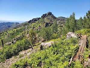
Bring your camera, not your paint brush! by Mike_W   Overview OverviewPaint Rock is one of the higher points in the Chiricahua mountains and could be hiked on a warmer day during the summer if the temps are not too intense. Most of the hike is a good trail but the final 0.2 miles involves some steep bushwhack and a 10-foot rock climb over a vertical section with good hand grips. This hike could be done by itself or combined with Chiricahua Peak or even Monte Vista Lookout if you don't mind the extra mileage. Hike If you are starting from Sycamore Campground, walk 1/3 mile up the road and look for the Mormon Canyon Trail #269 on the left side of the road. You may be able to park near this trailhead, but I believe there's only room for one vehicle. Start by taking the Mormon Canyon Trail #269. This trail crosses Turkey Creek within the first few minutes, then heads up a hill and into Mormon Canyon within a few minutes. You'll be hiking on the right side of Mormon Canyon for a while before the trail drops down into the canyon. At about 3/4 mile from the start of the Mormon Canyon trailhead, you should be in the canyon and see a stream. Water was flowing here in August when I was there. The trail heads up and out of the canyon and eventually, after about 3.1 miles runs into the Mormon Ridge trail with the same number (#269). About 1/4 mile from the top of the Mormon Canyon Trail, there's a burned fallen tree blocking the trail which you'll need to walk around. Near the top of the Mormon Canyon Trail and on top of the ridge you may find some wild raspberries depending on what time of the year it is.
The navigation here can be a bit tricky, and there are a few ways to go. Basically, you want to hike up the ridgeline to the base of a large rock formation. At the rock formation, you can go left or right. I went left on the way up but then came down on the other side of it. Both routes are steep but if you take your time, you will reach a bunch of aspens below the peak. From here you will want to head west and UP. You will reach a rock wall that's about 10 feet tall with some exposure. You'll have to be a fairly confident climber to get up this. There are some good hand grips along the way. This wall is probably the most challenging part of the hike. Once past this wall, the high point is roughly another 50 feet to the north. At the top is a registry and some great views all around. There are steep cliffs to the north, east, and west. Congratulations, you made it! To get down, there are 2 good choices that I found. #1 is you can go down the same rock wall that you went up, but sometimes going down is harder than going up. Option #2 - I found a slightly easier way down about 6 feet west of the 10-foot wall. Just make sure you have 3 points of contact at all times because there are some steep drop-offs to your west. Next, you need to squeeze through 2 densely packed trees, walk down a slope and you should be under the 10-foot wall again. From here, you should be able to go back down the same way you came up. I happened to do this hike on one of the hotter days in August, which I would not recommend. It was comfortable when the sun was behind the clouds, which seemed like only about 1/3 of the time. I was wishing it would rain a bit. There wasn't much breeze that day, either. Check out the Official Route and Triplogs. Leave No Trace and +Add a Triplog after your hike to support this local community. | |||||||||||||||||||||||||||||||||||||||||||||||||||||||||||||||||||||||||||||||||||||||||||||||||||||||||||||||