Route Editor

| Guide | ♦ | 9 Triplogs | 0 Topics |
details | drive | permit | forecast | route |
stats |
photos | triplogs | topics | location |
| 163 | 9 | 0 |
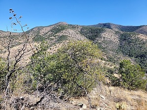
Even the Apache Indians had trouble with this hike! by Mike_W  Overview OverviewApache Peak, at an elevation of 7,710, is the high point of the Whetstone Mountains and is pretty remote and requires about 20 miles of driving dirt roads, with the last 4-5 miles requiring a capable 4-wheel drive high clearance vehicle. The drive takes about 2 hours if you do well, so you'll need to leave very early. You'll experience Arizona pin-striping on your vehicle. This means on the road you will see thorn bushes and other bushes that may scrape the side of your vehicle. My truck is so scraped up that I don't even care anymore. There's only a use-trail heading up the ridgeline which is quite overgrown and needs a lot of maintenance. There are areas of dense brush at times but the use-trail always seems to be present once you are on the ridgeline heading up to the peak. Hike First of all, the 20-mile drive to the trailhead is 20% of the challenge, and this is a pretty difficult hike overall. You'll definitely want to wear jeans/long pants to minimize getting scraped up. You may want to bring some pruning shears to cut some of the thorns in your way, as I did.
Exit the canyon wherever it is safe and then travel south/southeast up the hillside for at least 1/4 mile until you see a use-trail heading east/northeast toward the summit. It may be a bit messy & brushy at several places in this 1/4 mile area. Just look for clearings and use them the best that you can. You may want to bring small pruning shears with you, as I did, to clear away some of the thorns or thick brush as you continue toward the use-trail. Even on the use-trail, these small pruning shears were helpful especially where there were thorny bushes or trees since this trail was very overgrown in many areas. Continue up the use-trail, which in general is pretty easy to follow. If you don't see the trail, just keep climbing up the ridge and you will probably see it again after a few minutes. You will climb for a total of roughly 2.7 miles before reaching a false summit. Then, you will see the real summit of Apache Peak beyond that. Continue for another 1/2 mile to the summit for a total of 3.2 miles. If you started at the very end of the 4x4 road your distances will be slightly less by about 0.4 miles. There was a registry in a rock pile on the peak with some entries from as long ago as 1970! We were a bit surprised to see that someone summited 1 month before us. This peak doesn't get too many visitors in a year's time. Looking east we could see The Cape. Looking south, we could see French Joe Peak which was probably about 2/3 of a mile away. Further out to the south and a bit west we could see the Mustang Mountains, especially Mt Bruce also known as "The Biscuit" which had a rounded top, Northwest Dome to its left, then Mustang Peak, and then the Mustang Mountains high point left of that. In mid-November, it was a bit breezy on this peak and the high temp was supposed to be 56° F here. I felt a bit chilled here so I put on a windbreaker. Head back down the use-trail the way you came. You can follow the ridgeline further to the west and completely avoid the canyon on the way down if you'd like. If you hike far enough west, you can hike north where it's not so steep, and drop down to the 4x4 road. That's what we did on the way back and it worked out OK. If it looks too steep going north, just keep going west and look for a better spot to get to the road. Don't underestimate this hike. This hike feels longer because there is only a use-trail which is overgrown so much. You may spend a considerable amount of time getting from the wash to the use-trail, and then from the use-trail back to the road. It's also quite steep in many places along the ridgeline. Check out the Official Route and Triplogs. Note This is a moderately difficult hike. Leave No Trace and +Add a Triplog after your hike to support this local community. | |||||||||||||||||||||||||||||||||||||||||||||||||||||||||||||||||||||||||||||||||||||||||||||||